The West African rainy season runs between May and October, with local variations, including some parts of the region experiencing two peaks of rain within the season. In 2022, the rains arrived early and were in many regions above average, especially around a large area encompassing Lake Chad, leading to flooding from Mali to Cameroon. Nigeria and Niger saw the earliest onset of large floods in the first half of June, followed by Chad in July, Cameroon in August, and finally, Benin in September.
With at least 612 and 195 fatalities, respectively, the floods over Nigeria and Niger are among the deadliest in the countries’ history. The devastation in Nigeria is worse than the 2012 flood disaster with 34 out of 36 states and over 3.2 million people affected, including 1.5 million displaced and 2,776 injured. Several hundreds of thousands of hectares of land have been inundated, causing damage to more than 300 thousand homes and over half a million hectares of farmland.
Apart from the above average rainfall, climate change as well as the release of several dams have been cited as causes for the devastation.
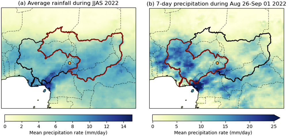
To analyse whether and to what extent human-caused climate change altered the likelihood and intensity of the rainfall, scientists from Nigeria, Cameroon, India, the Netherlands, France, Denmark, South Africa, Sweden, the US and the UK used published, peer-reviewed methods to perform an event attribution study, focussing on two aspects of the event: (1) The area-averaged seasonal rainfall from June to September over the Lake Chad catchment (Figure 1a), and (2) the seasonal maximum of the mean 7-day precipitation in June-September over the lower Niger catchment. (Figure 1b).
Main findings
- The flooding occurred as a consequence of above average rainfall throughout the 2022 rainy season exacerbated by shorter spikes of very heavy rain leading to flash floods as well as riverine floods. We therefore consider seasonal average rainfall over Lake Chad and 7-day maximum rainfall along the lower Niger Basin as the basis for our analysis.
- The flooding was further driven by the release of the Lagdo Dam in Cameroon, which is part of a river management system that was designed to be accompanied by another dam in Nigeria that has not been completed.
- The devastating impacts were further exacerbated by the proximity of human settlements, infrastructure (homes, buildings, bridges), and agricultural land to flood plains, underlying vulnerabilities driven by high poverty rates and socioeconomic factors (e.g. gender, age, income, and education), and ongoing political and economic instability.
- We also analyse how climate change from human activities, which includes greenhouse gas emissions as well as changes in aerosol pollution and other gases affect the rainfall in the region.
- To do this we analyse whether and to what extent human-caused climate change altered the likelihood and intensity of the seasonal rain over the Lake Chad Basin, and the peak 7-day rainfall over the lower Niger Basin. We look at both the historical record of weather data, and climate models with and without human activities altering the climate.
- Many of the available state-of-the-art climate models struggle to simulate the rainfall characteristics. Those that pass our evaluation test generally also show an increase in likelihood and intensity of extreme rainfall, in particular over the Lake Chad Basin.
- For the 7-day maximum rainfall over the lower Niger Basin, models and observations give very similar results, so we conclude that climate change made the event about twice as likely and approximately 5% more intense.
- For the seasonal rainfall over the Lake Chad region, we conclude that climate change made the event about 80 times more likely and approximately 20% more intense.
- Observations show a larger increase than the models, but there are large uncertainties in these estimates due to the high variability in rainfall in the region, and observed changes can have a variety of drivers, including, but not limited to, climate change. The increase in rainfall shown by the models is largely significant, but smaller.
- As a result of events like these becoming more likely as the planet has warmed, both events are not very rare in today’s climate, with a return time of about 1 in 10 years for the seasonal rain over the Lake Chad Basin and a 1 in 5 year event for the 7-day seasonal maximum over the lower Niger Basin.
- Looking at the future, for a climate 2°C warmer than in preindustrial times, models suggest that rainfall intensity will increase further, but not as strongly, suggesting that the strong trend observed in the last 30 years, in part, represents a change in the atmospheric dynamics e.g. through climate change-induced changes in ocean temperatures and a trend due to changes in aerosol pollution, in addition to greenhouse gases.
- Both current conditions and the potential further increase in extreme rainfall over both basins and the fact that the event was not unusual in the current climate highlight that there is an urgent need to drastically improve water management and reduce vulnerability to seasonal rainfall.


