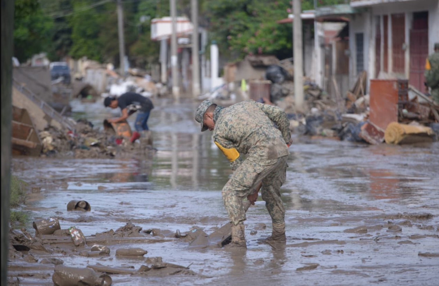
In early October 2025, three days of very heavy rainfall hit the Eastern coast of Mexico, causing widespread flooding, overflowing rivers, and numerous landslides.
Between October 8 and 10, heavy rainfall along Mexico’s Gulf Coast caused severe flooding and landslides across the states of Veracruz, Puebla, Hidalgo, Querétaro, and San Luis Potosí. At the time of writing, reports indicate at least 78 people have died and 23 remain missing (El Universal, 2025). A week later, 93 communities across these five states were still cut off (La Journda, 2025).
Around 50,000 homes were damaged, and thousands of schools, hospitals, and businesses were either heavily damaged or destroyed. Hundreds of thousands of residents lost access to electricity, telecommunications, transportation, and other essential services. The city of Poza Rica was among the hardest hit, with floodwaters reaching more than 3.5 meters in some areas (Daily Flash, 2025; JW, 2025; AA Americas, 2025).
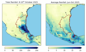
The months leading up to the floods had already been unusually wet, with above-average rainfall throughout the June–October rainy season. The most affected region—along Mexico’s eastern coast—experienced an exceptionally wet season, following an almost equally wet 2024.
To analyse whether and to what extent human-caused climate change altered the likelihood and intensity of the heavy rainfall that led to the floods, causing the damages and resulting in casualties, scientists from Mexico, the Netherlands, Sweden, the UK and the US used published, peer-reviewed methods to perform an event attribution study.
The region most affected by the event is on the Eastern coast of Mexico, covering the five affected states. Figure 1 shows the region of study, outlined in red, with orange crosses to reflect the short-term rainfall that directly contributed to the flooding. We analyse the wettest three-day period over the region each year: we denote the annual wettest three-day period each year as RX3day. As most of the country experienced a wetter-than-normal rainy season, saturating the ground and increasing the risk of runoff and flooding. To reflect these wet conditions during the months preceding the event we also analyse the seasonal rainfall from June – October.
Main Findings
- This region is highly prone to flooding, particularly due to its mountainous terrain where heavy rainfall quickly leads to overflowing rivers and landslides. It has experienced severe flood events in the past, notably during Hurricane Stan in 2005 and again in 2013, highlighting its vulnerability to extreme weather conditions.
- Remote villages and rural communities with a large proportion of Indigenous people were disproportionately impacted due to high exposure, chronic inequality and underinvestment in services and protection. These communities represent a diverse, Indigenous cultural heritage and yet were largely overshadowed by the impact in urban areas.
- At the national level, a forecast for heavy rainfall was issued by the National Meteorological Service (SMN) and the National Water Commission (CONAGUA), and communicated through government websites, bulletins, and civil-protection channels. However, when that weather forecast was translated into alerts at the local level, there were a mix of issues including the timeliness of alerts, the translation into potential impacts, as well as people’s understanding of the seriousness of the warnings and the action they should lead to. Improved translation of forecasts into potential impacts, risk education for the public and improved communication protocols can improve the system in the future. A full after-action review is required to identify specific gaps and improvements.
- We evaluated the contribution of both climate change and ENSO to extreme 3-day rainfall events, and also to the June-October rainy season. The onset of La Niña in September has heightened the likelihood of heavy rainfall throughout the season and intensified short-term downpours, which in turn led to the severe impacts observed.
- For the seasonal analysis, the observed datasets show opposing trends: ERA5 indicates an increase with global warming, while CPC and MxHighResClimDB show a decrease. This discrepancy is largely due to discrepancies in reconstructed rainfall trends prior to the satellite era (1979). The observation-based datasets also display diverging trends in three-day rainfall extremes: two indicate a decrease associated with climate change, while the third shows an increase.
- The fact that satellite-based observations and reanalysis exhibit different signs on the trend highlights the need for a better observational ground network (with more and better-maintained meteorological stations). Knowing the baseline is critical to determine if there are changes in precipitation due to climate change and to prepare for those changes.
- Climate models exhibit a mixture of trends in both short-term extremes and seasonal rainfall. This is in line with previous research and IPCC assessments that also show no clear trends in heavy rainfall in both of the IPCC regions capturing Mexico.
- These findings do not suggest that climate change plays no role, but rather highlight that its impacts can vary significantly across regions. Literature assessing weather station data indicates that climate change does affect heavy rainfall in Mexico; however, the patterns are uneven across regions and time, and partly influenced by regional dynamics. In recent years, a drying trend has been observed in the southern and central mountainous regions, while smaller, localized increases in rainfall have occurred in the north. Current large-scale climate models struggle to capture such patterns. Our findings thus underscore the need for better observations and higher-resolution data to fully understand regional climate impacts.
- Rapid urbanization has intensified the region’s flood vulnerability by replacing natural drainage areas with impermeable surfaces, increasing runoff and overwhelming drainage systems. In Poza Rica, one of the areas most severely affected, unplanned urban growth driven by economic opportunities from the oil sector, have increased people’s exposure to potential flooding. Additionally, the expansion of informal settlements in flood-prone areas has further heightened exposure to flood risks, amplifying the impacts of heavy rainfall events.
- Adaptation efforts should prioritise social and nature-based solutions that complement, rather than rely solely on, built infrastructure. Restoring ecosystems, strengthening community preparedness, and integrating risk into local planning can lead to more sustainable flood management, thereby reducing long-term vulnerability while enhancing resilience.


