Since 16 January, nine named storms have battered the western Mediterranean, with Spain, Portugal and Morocco hardest hit.
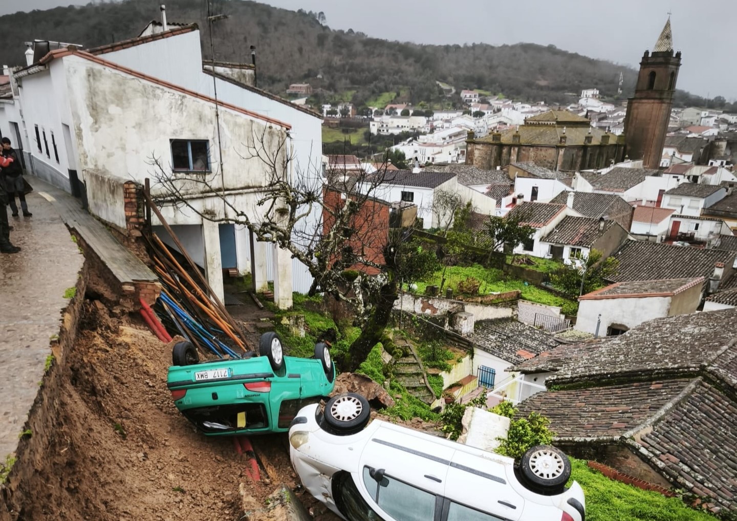
In Spain, flooding and infrastructure damage from heavy winds forced over 12,400 evacuations, affected 115,000 people in 19 villages in the Sierra de Cádiz, and led the Spanish Government to commit more than €7 billion in aid, with an additional €1.78 billion from the Andalusian regional government.
Portugal recorded six fatalities during Storm Kristin, with winds up to 202 km/h leaving one million people without electricity and causing widespread structural damage, and the Portuguese Government has already committed to supporting the reconstruction with a package of €3.5 billion.
In northern Morocco, flooding caused 43 deaths, displaced 300,000 people and inundated 110,000 homes, prompting a €280 million recovery plan.
While the high winds were exceptional and caused part of the damages, the most severe impacts are due to the heavy rain accompanying each storm that led to flooding in various regions. Later in the season the increasingly saturated soils also contributed to the flooding.
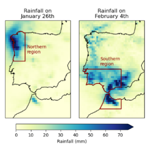
Researchers from Spain, Portugal, Morocco, the Netherlands, Sweden, South Africa Switzerland, India, Denmark, the United States, and the United Kingdom collaborated to assess the extent to which human-induced climate change altered the likelihood and intensity of the heavy rainfall event. To capture the range of impacts from the various rainfall events affecting the region, we analyse 1-day maximum rainfall (Rx1day) during the winter half year October–March. We focus on two regions that are climatologically different and have both been heavily impacted, Northern Portugal/Northwest Spain [40-44N 7–9.5W] and Southern Portugal/Southwest Spain, plus Northern Morocco [34-39N 3.5-10W]. In addition the study analyses whether there is a change in the frequency of the type of circulation pattern, leading to the storms.
Key Findings
- Early warnings were issued across all three countries, enabling authorities to take timely action. Evacuations were carried out, where proactive measures helped limit the impact on communities at risk. As a result, the death toll remained low. While any loss of life is one too many, the combination of advance warning and decisive response significantly reduced the overall human cost of the event.
- Densely populated urban centres, particularly where tourism-driven development has expanded into floodplains, as well as highly exposed, low-lying, sandy and eroding coastal towns, faced particularly high levels of exposure. In Morocco, high exposure was further compounded by social vulnerability, with a number of people living in informal settlements where housing quality, infrastructure and access to services are often limited. These underlying exposure and vulnerability factors significantly increased the potential for impacts when the hazard occurred.
- Nine named storms have occurred since mid-January across the Mediterranean, affecting parts of both study regions. However, the overall return period of the Rx1day event over the two larger regions is not exceptionally high, at around 40 years in the southern region and approximately 5 years in the northern region. In contrast, at local scales the event corresponds to a much rarer occurrence, with return periods well in excess of 100 years.
- To estimate if human induced climate change influenced heavy rainfall over the region we first determine if there is a trend in gridded observations in Rx1day in both regions. Over the observational record since 1950, the intensity of the event shows an increase of about 36% in the southern region and approximately 29% in the northern region. In addition, variability associated with the North Atlantic Oscillation further amplifies extreme daily rainfall in the southern region, contributing an additional 5% to Rx1day intensity. In the northern region this influence is very small, with just about 2% increase in intensity.
- To assess the extent to which the observed changes can be attributed to human-induced climate change, we combine observational evidence with climate model simulations. While observations indicate an increase in intensity, the models in the southern region do not reproduce this trend. In the northern region, while the modelled trend is weaker, the difference between modelled and observed trends is smaller, with a combined increase in intensity of about 11%.
- Analysis of the atmospheric circulation from 4 February 2026 reveals a familiar North Atlantic pressure dipole, with lower sea-level pressure over the North Atlantic and northern Europe, and higher pressure over the subtropics and the Mediterranean. This pattern is associated with high precipitation across northern and northwestern Europe. The spatial structure of the event resembles similar circulation patterns found in the historical data considered, but they are weaker in magnitude compared to the 2026 event, highlighting no apparent trend, but that 2026 had a much less stable atmosphere and high moisture availability, leading to high winds and high rainfall.
- An additional analysis estimating how the number of heavy rainfall events above a threshold has changed shows indications of an increase in the number of the most extreme events, particularly in the northern region. However, the results are highly dependent on the exact region and dataset chosen.
- In summary, while all lines of evidence are highly uncertain, especially in the southern region, and exact numbers strongly depend on the region and dataset chosen, they point towards an increased intensity of especially the most extreme heavy rainfall events.
- Despite all countries having shown progress in strengthening disaster management systems at varying degrees, there is still a need to better align national and municipal level early warning and response systems and capacity building at local level.
- To reduce future flood risks, routinely updated disaster risk information needs to combine vulnerability assessments, exposure mapping and future climate projections. Planning decisions should then embed and enforce risk reduction across land-use planning, building codes, and infrastructure investment decisions.
- Long-term impacts of the current floods can also be reduced if response and early-recovery measures are timely and properly implemented. For example, assessing structural damage to homes, schools, roads and public buildings, safe contaminant clean-up and disposal, water and waste management system rehabilitation, preventive measles vaccination in displacement camps, among others.


