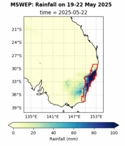
Coastal areas received over 100 mm of rain on each of these days, with especially intense rainfall on the Mid North Coast around Newcastle, Taree, and Port Macquarie.
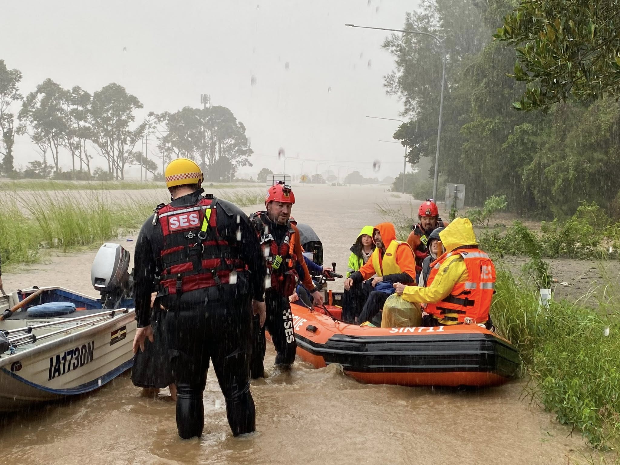
The floods claimed five lives, forced the rescue of 700 people, and left 50,000 isolated during and immediately after the event. While the full extent of the damage will become clear in the coming weeks, farmers have been hit particularly hard—many lost their livestock or the resources needed to feed their cattle.
To analyse whether and to what extent human-caused climate change altered the likelihood and intensity of the heavy rainfall that led to the floods, causing the damages and casualties, scientists from Australia, the US, the Netherlands, Sweden and the UK used published, peer-reviewed methods to perform an event attribution study. The study analyses the rain that fell over a 4-day period from May 19-22 and focuses on the Coastal New South Wales Region which received the most extreme rainfall and impacts as highlighted in Figure 1.
The heavy rainfall occurred in a region that is geographically and climatically transitional. It lies between southern Australia, which exhibits a clear drying trend associated with climate change in the colder months of the year, and northern Australia, where rainfall trends are more mixed. Additionally, the timing of the event—May—coincides with a seasonal transition from the warmer to the cooler part of the year. To capture both the spatial and temporal complexity of these features, we use two event definitions: one focusing on the season centered around May (April to June, AMJ), and another considering the wettest four days of the year irrespective of season. The annual definition is motivated by the historical record, which indicates that extreme rainfall and flooding can occur at any time of year in this region.
Main Findings
- The Mid-North Coast region has several major rivers with low-lying floodplains, and a coastal region housing the major urban centres. This region has endured a series of devastating disasters in recent years, including severe floods and bushfires. Consistent impacts from floods point to the high exposure of people and infrastructure to flooding in this region. The constant cycle of emergencies has left communities grappling with cumulative impacts and recovery fatigue. Rural communities bear the brunt of extreme weather, facing greater property and infrastructure damage, limited access to services, and isolation during disasters.
- A flood watch was issued 3 days in advance of the floods by the Bureau of Meteorology, which allowed for early action to relocate supplies and issue emergency evacuations for highly flood-prone areas, likely reducing impacts.
- Based on gridded data products for the region outlined in Fig. 1, we find that the extreme rainfall event over the study region is relatively common, expected to occur in today’s climate only once every 10 years when analysing April to June (AMJ) rainfall, and once every 3 years when considering the whole year. It is important to note the rainfall would have been a rarer and more extreme event in smaller, local regions, and some communities did experience the heaviest rain since records began.
- When comparing the AMJ event today with the same event in a 1.3°C cooler climate, we find a decrease in the likelihood and intensity of extreme rainfall such as observed by about 17%. However, when we look at RX4-day annually we find the event increases with global warming of 1.3°C. The best estimates for the increase in likelihood for the 2025 event associated with this warming is about a doubling, and the increase in intensity for an event of equivalent rarity as observed is about 10%.
- To quantify the role of human-induced climate change in these changes in likelihood and intensity we also analyse climate model data over the study region for the historical period. The models show substantial disagreement, with some projecting significant increases and others indicating decreases in heavy rainfall—both for annual and seasonal RX4-day, as well as when assessing changes in a 1.3°C warmer world. As a result, combining model simulations with observations to obtain an overarching result is not meaningful as different models clearly show changes that are incompatible.
- In addition to examining rainfall totals, we also assess whether the atmospheric circulation patterns driving heavy rainfall have changed over time. We compare an earlier period (1950–1980), when the climate change signal was relatively weak, with a more recent period (1994–2024), marked by a stronger influence of climate change. The analysis shows signs of a seasonal shift—atmospheric circulation patterns that could lead to similar heavy rainfall are now less common in March and more frequent in May. Moreover, present-day events tend to have more rainfall than their historical counterparts. However, not all analogues actually have rain associated with them and some are not very close analogues, thus rendering it difficult to draw firm conclusions.
- Understanding the influence of climate change on heavy rainfall in the Mid-North Coast is challenging. Consistent with previous studies, our analysis finds no clear trend, as climate models show strong disagreement—some projecting increases, others decreases in heavy rainfall. Observed changes in circulation further suggest that processes beyond the Clausius-Clapeyron relationship are involved. These factors interact in complex ways, and the relatively small size of the region compared to the scale of climate models makes it difficult to assess how these changes manifest within the scope of a rapid study.
- This uncertainty means that both drying and increased rainfall remain possible, so adaptation strategies must be designed to be flexible and responsive to a range of future conditions. Low-regrets adaptation measures that are beneficial in both wet and dry environments, such as nature-based solutions, water storage and diversification measures, and improved risk management can be useful options.


