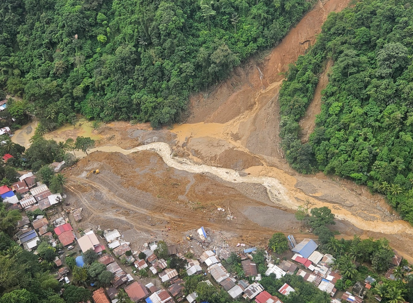
The event occurred after a series of smaller events that led to more localised flooding from mid-January onwards.
Researchers from the Philippines, the Netherlands, Germany, Sweden and the United Kingdom collaborated to assess to what extent human-induced climate change altered the likelihood and intensity of the weather conditions at the time of the most impactful floods.
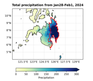
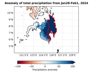
The impacts over Mindanao were primarily driven by the accumulated rainfall that persisted over Mindanao from 28 Jan to 1 Feb. To capture this event, we chose the maximum 5 days of accumulated rainfall during the December-February (DJF) period as the temporal extent. In terms of spatial extent, the Caraga and Davao regions that make up the east of the island of Mindanao were the most severely impacted, received the greatest rainfall totals, and are bounded to the west by mountains. Figure 1 shows the event region outlined in red.
Main findings
- The terrain is mountainous, rendering rainfall highly variable within the region, and thus uncertainties in relatively short records from a sparse observation network are high. Regardless, there is a strong upward trend in extreme rainfall in this region.
- To capture the heavy rainfall connected to the recent flooding that led to widespread devastation, we assess the 5-day maximum rainfall during December to February, the peak of the Northeast monsoon (Amihan) season. We find that in today’s climate, a heavy rainfall spell like this is expected with a 10% chance in any given year.
- We then assess to what extent El Niño had an influence on the heavy rainfall and found that El Niño typically leads to on average to less rainfall in this region during the Northeast monsoon. In other words, had it not been an El Nino year we would have expected the rainfall to be more extreme.
- To assess the role of climate change we first estimate if there is a trend in the observations associated with the warming up until today of 1.2C and find that there is indeed a strong trend, having made heavy rainfall such as observed more likely.
- To identify whether this trend is due to human-induced climate change we then also look at climate models with high enough resolution to capture precipitation over the study region. The available climate models do not exhibit a trend even for the models that were evaluated as “good”. This is surprising, as a comparably large body of scientific literature has identified an increase in heavy rainfall in most regions and seasons of the Philippines, including the region we studied.
- Given that the trend in the observations is large, there is probably an aspect of the atmospheric circulation that is systematically misrepresented by the models. This prevents us, without further detailed assessment of underlying processes and their representation in the climate models, to draw an overarching attribution conclusion that quantifies the influence of climate change on this event.
- Despite significant economic improvement, there is a higher-than-average rate of poverty across eastern Mindanao. Poverty negatively impacts communities’ ability to cope with extreme weather events, as their livelihood channels tend to be more limited and climate- sensitive, including farming and mining which the majority of residents are engaged in.
- Recent protracted conflict has contributed to limited access to and quality of basic services including healthcare as well as considerable displacement. Across displaced populations, a range of development indicators remain lower than the national average, which, coupled with limited health services, increase people’s vulnerability and reduce their coping capacity to natural hazards.
- In rural areas, intensified deforestation increases the risk of landslides and floods, whereas in cities, the loss of urban wetlands and tree cover coupled with clogged waterways enhance the risk of flooding. Across the region of study, construction in areas declared ‘no-build zones’ raises these dangers considerably.
- Policies, laws, and funding of disaster risk management have largely stalled over the past decades and are primarily geared towards ex-post strategies, notably response. Crucially, despite the presence of automated sensors for rainfall and stream level in the region, these have not been recording data since at least 2022. Further, while forecasts and warnings were issued every 12h, warnings have limited granularity on local risk and lack instructions on where and when to evacuate. However, Early Action Protocols are in place for floods and typhoons, and PASAGA is currently developing a pilot project on impact-based forecasting which can further improve anticipatory action.


