At the end of February, intense and localized rainfall triggered severe flooding and landslides across the Brazilian state of Minas Gerais, resulting in more than 70 fatalities (ReliefWeb, 2026). The city of Juiz de Fora was particularly affected and recorded its wettest month on record (INMET; G1, 2026). The first heavy rainfall events occurred between 22 and 24 February, causing significant landslides, followed by additional rainfall on 26 February. On the final day of the month, very high rainfall was also recorded further north in Minas Gerais.
According to national authorities, 72 deaths have been confirmed, 65 in the municipality of Juiz de Fora and seven in Ubá, while one person remains missing in Ubá. Nearly 10,000 residents have been displaced from the municipalities of Juiz de Fora, Ubá, and Matias Barbosa in Minas Gerais. The impacts of the heavy rainfall also extend to neighbouring states, including Rio de Janeiro and São Paulo, where flooding and landslides have been reported (ECHO, March 2026).

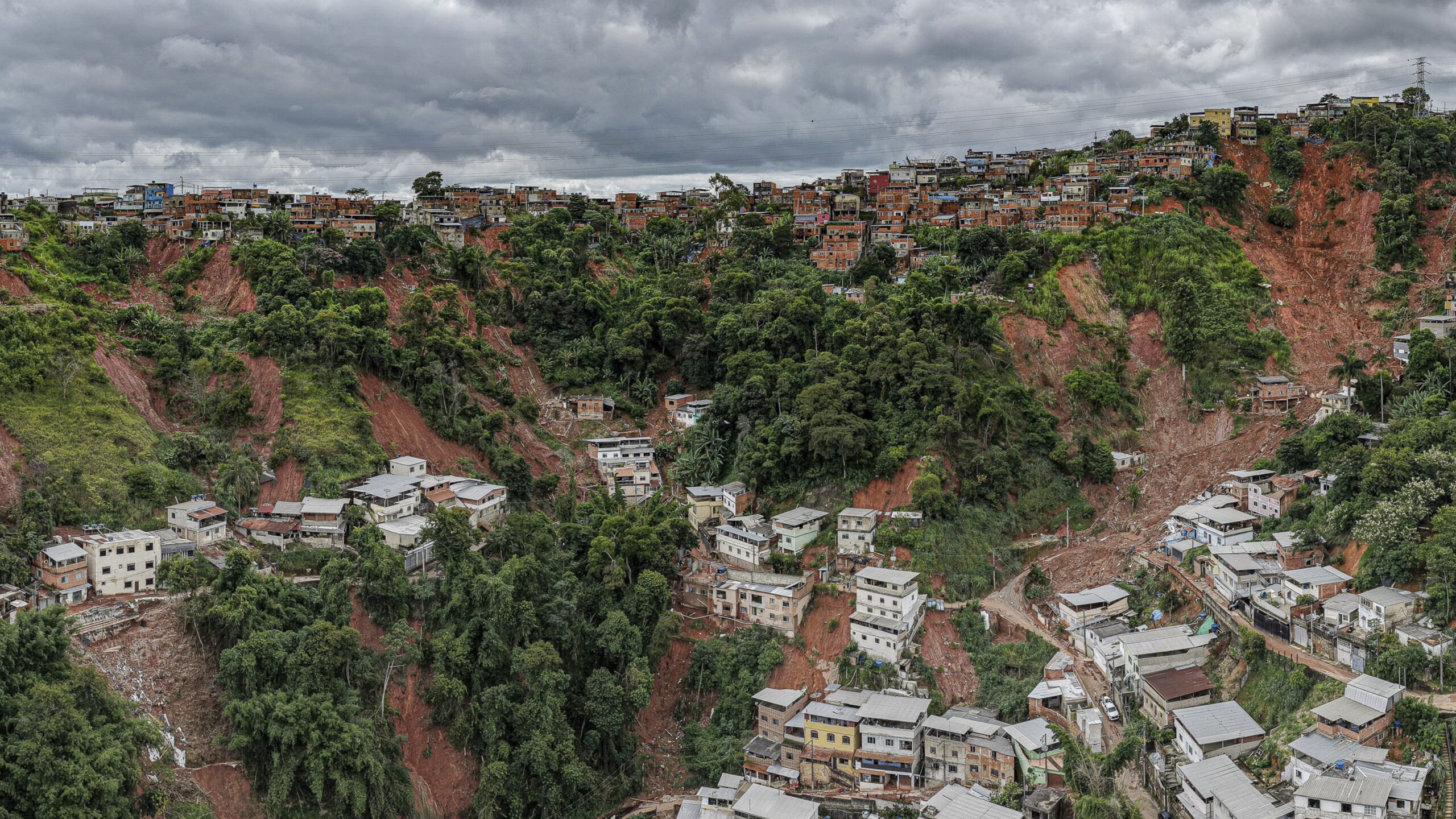
Photo: Ricardo Stuckert / PR
Researchers from Brazil, the Netherlands, Sweden, Denmark, the United States, and the United Kingdom collaborated to assess the extent to which human-induced climate change altered the likelihood and intensity of the heavy rainfall event that caused the landslides. While the landslides happened at the end of February, following a few days of very heavy rain, the whole month of February was exceptionally wet. To capture the range of impacts from the persistent rainfall affecting the mesoregion Zona da Mata, we analyse February rainfall accumulations. We also look at the 30-day maximum rainfall in the whole rainy season, to test if February rainfall behaves differently than the wettest 30 days overall. The spatial domain focuses on the most affected part of the river basin of the Paraiba do Sul river, encapturing the mesoregion Zona da Mata as well as parts of the state Rio de Janeiro (red outline, Fig. 1).
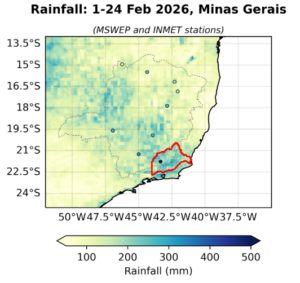
Figure 1: Map of accumulated rainfall in Minas Gerais from the 1st up to the 24th of February 2026 in MSWEP and available INMET weather stations. The study region is outlined in red.
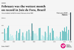
Figure 2: Accumulated February rainfall totals in Juiz de Fora using INMET data series that began in 1961.
Main Findings
- In Juiz de Fora, February’s exceptionally heavy rainfall saturated the soil, triggering widespread flooding and landslides. The severity of the disaster, however, was driven by the high exposure and social vulnerability. Risk assessments by Brazil’s National Center for Monitoring and Early Warning of Natural Disasters (Cemaden) had previously identified around 130,000 residents living in high-risk zones, placing Juiz de Fora among the 10 cities in Brazil with the highest proportion of people living in such risky areas.
- Urbanization of the hills initially involved well-built housing supported by skilled labor. Historic growth along the Paraibuna River valley and northwest transport corridors, later reinforced by industrial districts and factories, drove residents to settle in lower-quality homes on steep slopes and valley bottoms. Rapid, largely unplanned expansion in these areas, often with poor drainage, low vegetation and weaker infrastructure, created high-risk zones for rainfall events, particularly in districts such as Benfica, Vila Esperanca, and Santa Cruz.
- Cemaden and INMET issued multiple warnings and alerts ahead of the heavy rainfall. While these alerts accurately indicated high landslide and flood risk, evidence suggests that some residents did not fully receive, understand, or know how to act on them. Factors include topographical constraints that limit siren effectiveness, long-term residence in hazard zones, and lack of accessible evacuation options. This highlights that warnings alone are insufficient, and must be complemented by clear guidance, risk education, and practical evacuation planning to strengthen community preparedness.
- Across the study region, gridded rainfall data show moderately high precipitation in February, with a return period of about 1 in 10 years. However, when compared with observations from the one available local weather station in the study region, the gridded products significantly underestimates the intensity of the event in Juiz de Fora, where the local return period is several 100 years.
- To estimate if human induced climate change influenced heavy rainfall over the region we first determine if there is a trend in observations in February precipitation, finding that observed trends in February total rainfall are highly variable, with the four datasets used showing for the two longest datasets no trends, while the two shorter ones show an increase between 25 and 60%.
- Climate models indicate no trends in February rainfall under current conditions in the small, highly variable study region, but project notable increases of about 7% with future warming. A pattern that aligns with findings from existing studies and IPCC assessments in the larger region that show a wettening trend emerging from 1.5C global warming onwards. Thus, an emerging trend is apparent, and might have contributed to the localised events even if it is not yet evident across the wider region.
- More intense rainfall, especially over the course of a month, saturates slopes, reduces soil stability, and increases the likelihood of slope failure. As a result, landslide hazard remains unlikely to diminish but might increase further.
- Given the large population already living in high-risk areas, risk reduction in Juiz de Fora requires viable, largely incremental adaptation measures. These can include targeted slope stabilization, improved drainage, reinforcing housing foundations, expanding early warning infrastructure, and community-level preparedness programs. Strengthening land use enforcement can gradually reduce exposure, while addressing the structural inequities that concentrate among low-income households.
- Brazil’s past flood responses have quickly adapted existing social protection systems during climate hazards. By advancing payments, expanding coverage, and providing targeted emergency transfers, the government delivered timely support to affected populations. As climate change shortens intervals between disasters, public policy must go beyond planning, ensuring sustained investment in key sectors like health, with systems resilient to both climate impacts and disasters.


