
A widespread heat wave is forecast to affect much of the central and eastern United States over the Fourth of July weekend, driven by a strong “heat dome”, a high pressure system sitting over the US, bringing moisture and warm air from the Gulf of Mexico (Al Jazeera, 2026). Daytime high temperatures are expected to be over 100°F (32–38°C+), with heat index values reaching 105–115°F (41–46°C) in some areas because of high humidity (CBS News, 2026). While the heat index, which combines temperature and humidity, is commonly used in US weather forecasts, another measure for humid heat extremes especially designed to measure the impact of humid heat during physical activity is the Wet Bulb Globe Temperature (WBGT, see box below). A heat index of 105°F is roughly equivalent to 28-30°C WBGT. Above 28°C physical activities such as playing football become extremely dangerous for even healthy and young people (WWA World Cup Report, 2026).
The greatest impacts are expected from the Midwest through the Mid-Atlantic and Northeast, with many major cities, including Chicago, Detroit, Washington, D.C., Philadelphia, and New York, under heat alerts (Guardian, 2026). High overnight temperatures will provide little relief, while high humidity is increasing the risk of heat-related illness, especially during outdoor holiday events (Weatherchannel, 2026).
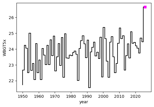
Figure 1: Time series of annual WBGTx5x in ERA5 data for the study region, with the 2026 July event highlighted in pink.
Key Messages
- Heatwaves are the deadliest type of extreme weather, with hundreds of thousands of people dying from heat-related causes each year. Extreme heat tends to be particularly dangerous in cities due to the urban heat island effect. Temperatures also vary widely within cities, with historically redlined districts up to 7°C hotter than non-redlined neighbors.
- The heat is being driven by a persistent high-pressure system, a weather pattern characteristic of heatwaves across the US. However, this same pattern now leads to higher temperatures than it did in the past because the underlying climate has warmed.
- WBGT (see box below) reached the highest observed values on record across the study region (figure 1). It is still a relatively rare event even in today’s climate, that has warmed by 1.4°C due to the burning of fossil fuels. In a 1.4°C cooler climate, WBGTs as high as those forecast in early July 2026 would have been so extreme as to be virtually impossible.
- Maximum temperatures and minimum temperatures are also increasing with global warming, but less rapidly than WBGT, with maximum temperatures even showing a slight decrease over a few decades in one dataset. This highlights the importance of assessing both temperature and humidity to understand the impact of climate change on human health.
- Cities like New York, Philadelphia and Chicago have activated heat action plans, which include measures such as opening cooling centres, suspending power shutoffs for late payments and a “heatline” allowing people to speak directly to a nurse. However, there remains an urgent need for wider accelerated roll-out of heat action plans in light of increasing vulnerability, driven by the intersecting trends of climate change and population ageing, paying also special attention to the mental health impacts of extreme heat (Stewart-Ruano et al., 2025). Cities are hot-spots for heat risk, so reducing the urban heat island effect through measures that increase cooling green and blue spaces is essential to reduce future exposure.
- While air conditioning is largely protective of the general population in the US and Canada, it highlights those without access to air conditioning due to economic constraints, outdoor job requirements, or limited mobility as most vulnerable to health impacts. Further, the potential for high energy consumption as millions of people turn on their home air conditioners during the holiday weekend will stretch electricity grids, creating the possibility of power outages which would expose a larger part of the population to oppressive heat and humidity.
- The WBGT observed during this event exceeded the previous record by an exceptionally large margin. While such events are generally classified as record-breaking extremes, the terms record-shattering and record-smashing have recently been introduced in the scientific literature to distinguish events that exceed previous records by unusually large margins. Research shows that the likelihood of shattering records is proportional to the rate of warming, meaning that the very fast increase in greenhouse gas emissions in recent years has made such events much more likely.
| Wet Bulb Globe Temperature To measure the combined effect of environmental factors on human heat stress, Wet Bulb Globe Temperature (WBGT) is used as a composite index, combining humidity, radiant heat (such as direct sunlight), and air movement, all of which affect the body’s ability to regulate its internal temperature through sweating and heat exchange. By capturing these interacting variables, WBGT provides a more physiologically relevant assessment of thermal strain, particularly during outdoor physical activity. Consequently, it is widely applied in fields such as sports science and occupational health (Grundstein et al., 2023). In this study we approximate WBGT using temperature and humidity (per Zhang et al., 2024) – which means results apply best to a sheltered and shaded area, without the heating effect of direct sunlight or the cooling effect of wind. |
Overview of heatwaves in North America
Recent research has highlighted the growing intensity and impacts of heatwaves in North America, including the US. At a broader regional scale, warming trends at continental scales show similar tendencies. Gutiérrez et al, 2021 reported warming rates between 0.2°C and 0.3°C per decade across the Central America region, with higher rates of up to 0.5°C per decade in Mexico and southern Baja California in the last 30 years. Additionally, extreme heat episodes have noticeably increased in frequency across most regions of the continent (Seneviratne et al, 2021). Under continued global warming, hot extremes will become more frequent, more intense and longer-lasting (IPCC, 2021).
In an attribution study over the wider region over Mexico and the US, and looking not only at greenhouse gases but also aerosol forcings and internal variability, Gracia-Martinez and Bollasina (2021) found that in addition to anthropogenic greenhouse gases increasing the likelihood of heatwaves, aerosol-induced cooling, in particular between 1950 and 1980, masked these trends, even causing small cooling trends in some locations. This region stands out as a global hotspot, both in observations and projections, with stronger trends in absolute summer maximum temperatures in northern Mexico and the southern U.S. and stronger trends in nighttime temperatures in southern Mexico and Central America (Suarez-Gutierrez et al. 2020).
A prominent example of recent extreme heat is the 2021 PNW heatwave, which provides important context for understanding extreme heat and its drivers in the US. A study by Fleishman et al., 2025 analysed over 70 research papers covering the heat wave that occurred across the Pacific Northwest of the United States and Canada in late June 2021. This study found that anthropogenic climate change has increased the mean daily temperatures, although it remains unclear whether trends in extreme daily maximum temperatures are increasing more rapidly than the trend in extreme daily mean temperature. The likelihood of such an event has increased substantially as compared to the pre-industrial era, ranging from 700% to infinity. Furthermore, the likelihood of similar summer heatwaves is expected to increase significantly under continued warming. Supporting this, Chen et al., 2023 found that day-time maximum temperatures in major cities in the Western United States were 10 to 20°C higher than the 10-year average maxima. Zhang et al., 2023 found that the heat dome associated with the PNW heatwave of 2021 accounted for approximately half of the observed temperature anomalies, and that extreme temperatures associated with such heat domes are increasing faster than the background global rise in temperature.
Studies specifically looking at humid heat found WBGT have increased substantially across the southeastern United States and the Gulf Coast over recent decades. This trend has been driven primarily by rising atmospheric moisture, with increases in humidity contributing more strongly to escalating heat stress than temperature increases alone (Scheff and Bouroughs, 2023; Milrad et al., 2025). These changes are found to be particularly pronounced in densely populated coastal urban areas, where the interaction between increasing humidity, urban heat island effects, and limited nocturnal cooling has intensified nighttime heat exposure (Wodzicki et al., 2024; Milrad et al., 2025) .
As a consequence of climate change, there is also a growing body of evidence demonstrating that impacts of heatwaves on human health are also increasing. Narayanan and Keellings 2025 found that in the Southwest and Southeast regions of the US, heat-related mortality is increasing at a higher rate than heat severity. In the Southwest and West, the unevenness of population distribution helps to explain the correlation between extent of the event size and mortality outcomes.
Analysis of trends in extremes
Event definition
A large heatwave is affecting the northeastern US and eastern Canada, peaking over both Canada day (1st July) and US Independence Day (4th July). To examine the effect of climate change on extreme heat, we focus on the region bounded by the box to 95°W to 67°W and 35°N to 50°N. Figure 2 shows the anomaly in the 5-day average of daily maximum wet bulb globe temperature (WBGT) relative to a 1991-2020 climatology of summer (June-August) temperatures. The anomalous heat migrated from west to east, with widespread extreme heat persistent over the study region for more than a week.
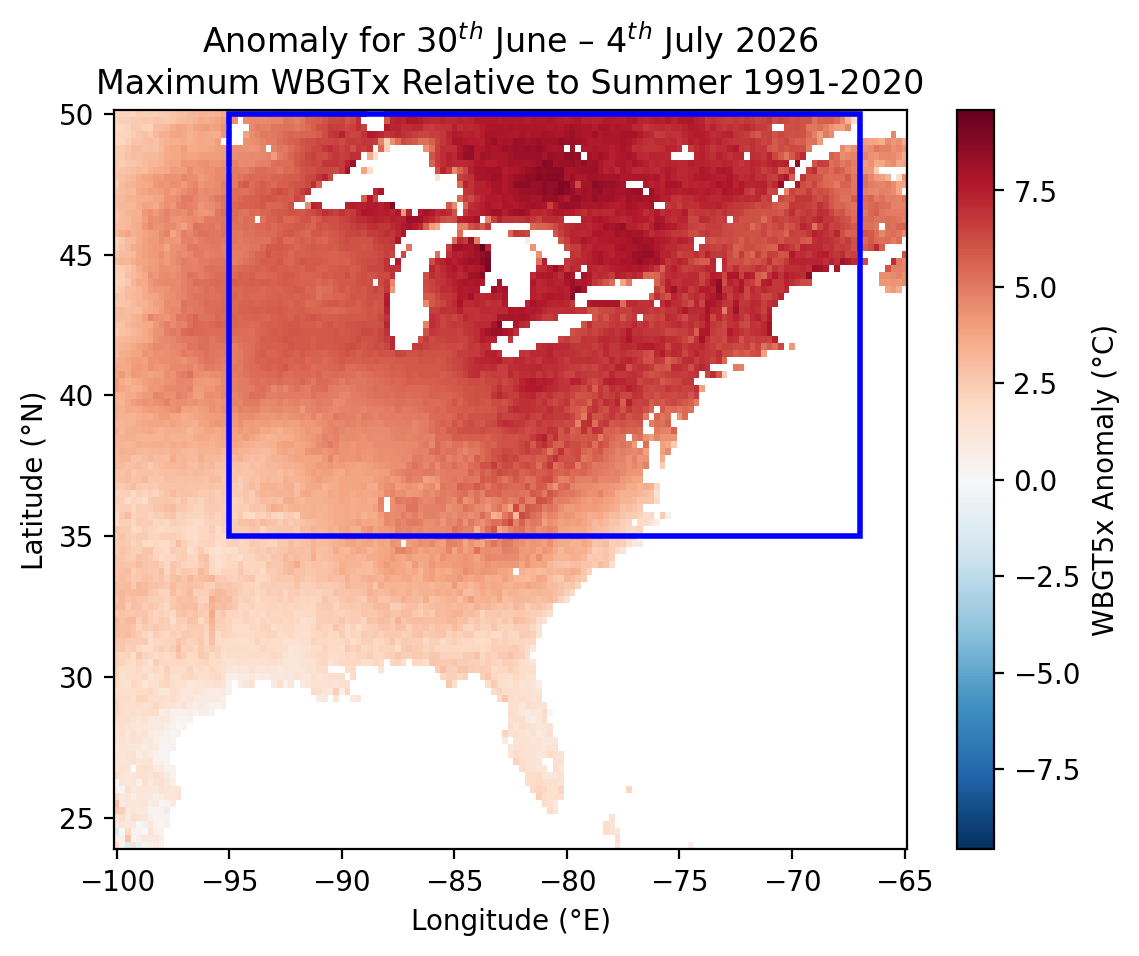
Figure 2: 5-day mean of WBGTx for 30th June to 4th July 2026 relative to the standard WBGTx values based on a summer (JJA) climatology for 1991-2020.
Humidity was a key factor driving this event, both in terms of impacts and event rarity. The 5-day maximum period of daily maximum (Tx5x) and daily minimum temperatures (Tn5x) is within sample compared to the climate of the last 35 years (Figure 3). However the 5-day maximum period of daily maximum wet bulb globe temperatures (WBGTx5x) has been a record-shattering extreme.
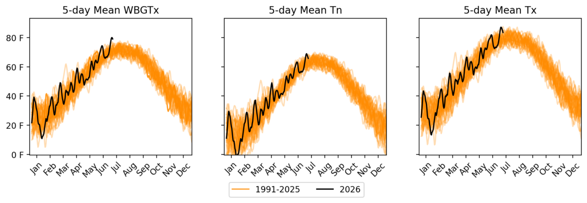
Figure 3: Rolling 5-day means of WBGTx, Tx and Tn for the study region.
Results
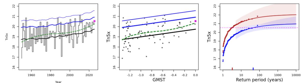
Figure 4: Left and centre: Time series of annual WBGTx5x in ERA5 data for the study region, plotted against both time (left) and global mean temperatures (centre). The event is shown with the pink box. The loess-smoothed trend is shown with the green dashed line and the fitted statistical model that varies with GMST is shown with the black and blue lines, showing the event (black line), and the 1-in-6 (bold blue) and 1-in-40-year (lighter blue) return period event magnitudes. Right: Statistical fits to WBGTx5x, in ERA5. The influence of the current GMST is shown with the red vs blue probability curves, showing the present (2026) vs pre-industrial warming levels. The magnitude of this year’s event is highlighted with a horizontal magenta line.
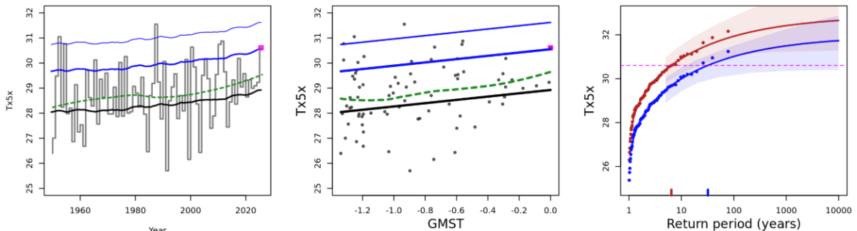
Figure 5: As in figure 4, but for Tx5x (upper) and Tn5x (lower)
At the time of this analysis, the event was still unfolding. There is a strong increase in 5-day temperatures (minimum and maximum) and wet bulb globe temperatures (Figure 4), with the WBGTx5x event well outside of sample. The return periods are therefore estimated using a combination of reanalysis, analysis and forecast data available within ERA5 as of 01/07/2026. Our analysis suggests that the likelihood of an event to occur at some point during the year in the present climate is over 1 in 200 years for WBGTx5x and a relatively common event (1 in 3 and 1 in 6 years) for Tn5x and Tx5x respectively (Table 1).
| Return Period (ERA5) | Return Period Used In Attribution | |
| WBGT5x | 235 (32.4, Inf) | 100 |
| Tn5x | 3.27 (1.94, 8.43) | 3 |
| Tx5x | 6.45 (3.62, 25.1) | 6 |
Table 1: Estimated return periods of WBGTx5x, Tn5x, and Tx5x annually over the study region over eastern US and Canada in the combined ERA5 reanalysis, analysis and forecast dataset.
According to our analysis, this heatwave in North America has become much more likely and intense as a result of human-induced climate change. When the planet was approximately 1.4°C cooler, such a warm and widespread event would have been much less likely, and an event with these specific impacts driven by persistent, humid heat would not have happened in a preindustrial climate. For the attribution analysis, we assess the change in likelihood of a 1 in 100 event in today’s climate, as even rarer events were unlikely to be observed at any level of rarity in a preindustrial climate. Nonetheless, an infinite return period is still observed for this event as well, even in the dataset DayMet that shows a slightly negative trend over the region in Tx5x. The data in DayMet does not include the 2026 event. The rate of warming for WBGTx5x is also greater than for Tx5x or Tn5x, indicating that humid heat extremes are likely an emerging risk in the region with future warming (Table 2).
| Probability Ratio | Intensity Delta (°C) | ||
| WBGT5x | ERA5(1950-2026) | Inf (4970, Inf) | 1.50 (0.269, 2.16) |
| DayMet(1980-2025) | Inf (0.0820, Inf) | 0.520 (-0.449, 1.64) | |
| ERA5(not incl. 2026) | Inf (4.90, Inf) | 0.792 (0.0899, 1.55) | |
| Tn5x | ERA5(1950-2026) | 11.0 (1.17, Inf) | 1.05 (0.110, 2.00) |
| DayMet(1980-2025) | 6.08 (0.645, Inf) | 0.706 (-0.372, 1.85) | |
| ERA5(not incl. 2026) | 9.50 (0.971, Inf) | 1.02 (-0.0240, 1.97) | |
| Tx5x | ERA5(1950-2026) | 4.68 (0.899, 1650) | 0.920 (-0.0753, 1.82) |
| DayMet(1980-2025) | 0.520 (-0.449, 1.639) | -0.710 (-3.92, 1.16) | |
| ERA5(not incl. 2026) | 3.48 (0.703, 178) | 0.783 (-0.285, 1.77) |
Table 2: Changes in likelihood and intensity in maximum annual 5-day WBGTx, Tx, and Tn, associated with global warming since a preindustrial climate (approximately 1.4°C cooler than present).
Circulation Analogues
Figure 6 shows the atmospheric circulation and surface temperature conditions associated with the 2 July 2026 circulation pattern with historical (1950–1979) and recent (1994–2023) climatologies over North America. The top row shows the 500 hPa geopotential height (Z500), where the event is characterized by a pronounced upper-level ridge over the eastern United States, reflected by strong positive height anomalies that are favorable for persistent hot conditions. The climatological comparison indicates only small changes in Z500 between the historical and recent periods, although many of these differences are not statistically significant. In contrast, the middle and bottom rows show significant warming in both maximum (Tmax) and minimum (Tmin) temperatures in recent climatology relative to the historical period. General increases of approximately 1-3°C are evident across much of North America, with the strongest warming occurring over the western United States, parts of the Northeast, and the Great Lakes region.
The 2 July 2026 event exhibits exceptionally high daytime temperatures exceeding 32-40°C across large portions of the United States, accompanied by high nighttime temperatures, illustrating that the event developed under a strong synoptic-scale ridge superimposed on a warmer modern climate. Together, these results suggest that while large-scale circulation changes have been relatively small, the warmer background climate has substantially increased the intensity of both daytime and nighttime heat during the extreme event.
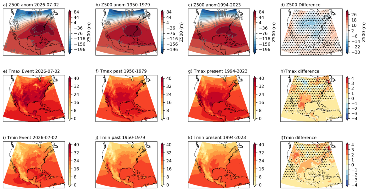
Figure 6. Changes in atmospheric analogues. (a) 500hPa geopotential height field (m) for the event, 2 July 2026. b) Composite of the top 28 analogue days from the past period, 1950-1979. c) Composite of the top 28 analogue days from the present period, 1994-2023. d) Difference between the composites of past and present (present minus past). e-h) as in a-d for the daily maximum temperature field (°C). i-l) as in a-d for the daily minimum temperature field (°C). Z500 used to identify analogues in all plots. Dots signify regions where the signal is not significant based on a two-sided t-test.
The Effect of El Niño
There is a developing El Niño in the Pacific, that has been forecast to become extremely strong over the summer months. However, the effect of El Niño is weak over northeastern North America and is associated with a minor cooling trend in the summer (Wang et al 2012 ; Jong et al., 2020).
The inclusion of the relative JJA Niño3.4 (summer relative El Niño index) was tested in this analysis, and found to have no major improvement of the model fit. When included, the sign of the effect of the summer El Niño index was cooling, but minor, over this region
Vulnerability and exposure
In addition to the heat and humidity itself, an array of exposure and vulnerability factors can increase the propensity for people to be impacted. In this section, we briefly highlight drivers of vulnerability and exposure in the midwestern and eastern United States, and include event-specific context which helps explain the potential impacts from this event.
In particular, this July 2026 heatwave occurs on the eve of the 250th Independence Day celebrations across the US on July 4th with millions of Americans expected to spend time outdoors at local parades, barbecues, beaches and fireworks shows. The combination of heat and humidity is particularly dangerous because the humidity prevents sweat from evaporating, counteracting the body’s main mechanism to cool down (Bright et al., 2025). This increases cardiovascular strain, and dehydration and can lead to heat exhaustion and heat stroke. Extreme heat tends to be particularly dangerous in cities due to the urban heat island effect. Temperatures can also vary widely within cities, with historically redlined districts up to 7C hotter than non-redlined neighbors (Hoffman et al., 2020). For example, in New York City a study found that black individuals were more likely to die during heatwaves than other races/ethnicities, and that deaths were higher in places with higher daytime summer surface temperature compared to places with more green space (Madrigano, 2015). On average, across 169 urban areas in the US, people of color live in census tracts with higher surface urban heat island effects than non-Hispanic whites (Hsu, A. et al, 2021).
Extreme heat is well-studied in the United States, with episodes such as the 1995 Chicago heatwave with over 700 heat-related deaths informing our understanding of heat risk, and especially the importance of social isolation as a driving factor of heat-related deaths in cities (Kilnenberg, 2002). Being confined to a bed and living alone were found to be the strongest risk factors, while having working air conditioning and access to transportation were protective (Semenza, 1996; Sera, 2020).
Air conditioning and power grid strain
The US generally has very high air conditioning penetration with at least 88% of households across the country using it (EIA, 2020). Similarly 68% of Canadian households report air conditioning access, and up to 83% in Ontario (Government of Canada). However, in some cases economic constraints such as energy costs can prevent some people using their A/C or determine how long they will turn it on, potentially limiting effectiveness (Sheridan, 2007). Those who have access to air conditioning and use it are largely protected from the impacts of extreme heat. A/C use also contributes to increased energy demand which can stretch the electricity grid and prompted the US Dept of Energy to declare an Energy Emergency Alert to direct a key electrical grid operator, PJM Interconnection, to maintain reliability in the grid and use back up generation resources (US Dept of Energy, 2026). A novel study from Bone et al in 2025, suggests combining A/C and fans can substantially reduce energy consumption while maintaining protective cooling (Boon et al 2025). The people at highest risk during this heatwave are those who won’t have access to air conditioning. That includes low-income residents in cities where they cannot afford air conditioning, older adults with limited mobility who cannot easily get help, people without houses who live and sleep outside, and people with jobs that require them to work outdoors such as delivery drivers and construction workers (Sera, 2020; Smith et al, 2024).
Early Warning Systems
Heat-health early warning systems, coupled with public health information and heat action plans, are crucial to reducing the acute impacts of extreme heat. (Toloo et al 2013, Matzarakis and Giannaros 2025 ) One of the first heat early warning systems in the United States was established in Philadelphia in 1995 following an extreme heat event that is estimated to have resulted in 118 deaths in 1993. Already in its first three years of operation it was estimated to have saved 117 lives in Philadelphia. (Ebi et al 2004) Today, heat-health early warning systems exist across the US and Canada, providing early alerts when dangerous levels of heat are on the way, and, in coordination with local authorities, activating protective measures such as cooling centers, hotlines, emergency health services, among others. In the US, the National Integrated Heat Health Information System (NIHHIS) is the interagency coordination mechanism working at the Federal level to build heat resilience across the US, including through the expansion of heat-health early warning systems. (NIHHIS 2026). In Canada, heat early warning systems are co-produced by Environment and Climate Change Canada and Public Health Canada, in coordination with provincial and local authorities (ECCC 2026).
City heat actions
Cities around the US and Canada are taking short and long-term action, with many specifically focusing on the vulnerable groups without air conditioning access. New York City (NYC) has opened cooling centres, expanded hours for public pools, created pop-up cooling stations for outdoor workers, and dedicated 21 mobile cooling vans to provide in-home wellness checks to older adults during the heatwave (NYC, 2026). NYC has also expanded air conditioning access for low-income residents, and focused on reducing the urban heat island effect through urban forestry initiatives, and by adding white reflective coating to city rooftops (NYC Cool Roofs, 2013; AccessNYC, 2026). In Philadelphia, the city declared a heat health emergency and activated the city’s “Heatline” which is a helpline operated by the Philadelphia Corporation for Aging that provides health safety tips, connects callers to cooling centers, and allows residents to speak directly with health department nurses regarding heat-related illnesses (Phila, 2026). The city has also suspended utility shutoffs for non-payment and sent out Homeless Street Outreach teams to provide services for people sleeping or living outside (Department of Public Health, 2026). Regarding longer-term adaptation measures, the city’s Climate Action Playbook prioritizes increasing access to green spaces and the city has previously passed ordinances to encourage cool roofs in new construction and piloted free installation (City of Philadelphia 2021, WHYY 2025). In Toronto, the city cancelled outdoor watch parties for local World Cup matches due to the extreme heat and opened up over 500 cooling centres, and mobile drinking water trailers, an activation of Toronto’s Heat Relief Strategy (Toronto, 2026a, Toronto 2026b). Toronto is also implementing longer-term adaptation strategies for extreme heat including adoption of Thermal Comfort Guidelines which include considerations for buildings, neighborhoods, transportation systems, among others (Toronto 2025).
Data and methods
A1.1 Observational data
We first use observational and reanalysis data to estimate the return period of a similar event in the present day and to assess the historical trends with increasing GMST. The datasets used are as follows:
- ERA5 – The European Centre for Medium-Range Weather Forecasts’s 5th generation reanalysis product, ERA5, is a gridded dataset that combines historical observations into global estimates using advanced modelling and data assimilation systems (Hersbach et al., 2020). We use maximum temperature, minimum temperature and dew temperature data from this product at a resolution of 0.25°×0.25°, from the years 1950 to present. Reanalysis is available until the end of May 2026, and extended with European Centre for Medium-Range Weather Forecasts (ECMWF) analysis data from June 1st to June 30th and forecast data from July 1st to July 4th.
As a measure of anthropogenic climate change we use the (low-pass filtered) global mean surface temperature (GMST), where GMST is taken from the National Aeronautics and Space Administration (NASA) Goddard Institute for Space Science (GISS) surface temperature analysis (GISTEMP, Hansen et al., 2010 and Lenssen et al. 2019). To remove the effect of the El Niño – Southern Oscillation on global mean temperatures, we use a four-year running mean of the GMST, centred on the third year.
As a measure of the El Niño – Southern Oscillation cycle (ENSO) we use the detrended Niño3.4 index. This is computed from NOAA’s ERSST v.5 sea surface temperatures, by subtracting the mean tropical SST (20S-20N) from the mean SST over the Nino3.4 region (5S-5N, 170W-120W). This index is therefore adjusted to remove the linear trend associated with climate change as proposed in van Oldenborgh et al., 2021, but without rescaling each calendar month.
A1.2 Statistical methods
Methods for observational data analysis are used according to the World Weather Attribution Protocol, described in Philip et al., (2020), with supporting details found in van Oldenborgh et al., (2021), Ciavarella et al., (2021), Otto et al., (2024) and here. The key steps used here are: (3) trend estimation from observations and (6) synthesis of the attribution statement.
In this report we analyse the time series of June-July-August- maxima of 5-day daily maximum and minimum temperatures and WBGT over the study region, which is land areas bounded by 95°W to 67°W and 35°N to 50°N. A nonstationary GEV distribution is used to model these variables. The distribution is assumed to shift linearly with the covariates, while the variance remains constant. For each time series we calculate the return period and intensity of the event under study for the 2026 GMST and for 1.1°C and 0.6°C cooler GMST: this allows us to compare the climate of now and of the past periods (based on the Forster et al., 2026), by calculating the probability ratio (PR; the factor-change in the event’s probability) and change in intensity of the event.
In order to examine the effect of the ENSO phase on Tx5x and Tn5x alongside that of increasing GMST, we extend the nonstationary model to accommodate an additional covariate. The variable of interest, X, is assumed to follow a GEV distribution in which the location parameter varies with both GMST and ENSO:
X ~ GEV(,, | 0, 0,,, T, I),
where X denotes the variable of interest, 5-day maximum or minimum temperatures or WBGT; T is the smoothed GMST; I is the detrended Niño3.4 index; 0, 0 and are the location, scale and shape parameters of the nonstationary distribution; and , are the trends due to GMST and ENSO, respectively. As a result, the location and scale of the distribution have a different value in each year, determined by both the GMST and Niño3.4. Maximum likelihood estimation is used to estimate the model parameters, with
=0 + T+I and =0.
A1.3 Circulation Analogues
Atmospheric flow analogues can be used to assess changes in the intensity of dynamically similar events or changes in the frequency of occurrence of particular circulation patterns (Vautard et al., 2023; Jézéquel et al., 2018, Thompson et al 2024). Here we use ERA5 data to assess analogues identified from 500 hPa geopotential height (Z500) since 1950, to detect changes in the frequency of circulation patterns similar to those associated with the heatwave.
To identify the most similar events, we compute the Euclidean distance between the Z500 anomaly field of 2 July 2026 and every other day (1950–2024) over the region bounded by [120°E to 60°E, 10° to 55°N] for the season of June-August (JJA). To avoid double-counting persistent events, the identified events must be separated by at least 5 days. The region and circulation variables were determined by assessing the event itself and earlier current understanding of the circulation drivers of similar events (Holgate et al 2023).
To detect trends in the circulation pattern and intensity since 1950 we identify the closest 28 analogues across the two periods (1950-1979 and 1994-2023). This corresponds to the closest 1% of days in each period. The average weather conditions associated with the two sets of analogues – called ‘composites’ – are then compared to assess differences between the two periods. We also assess the change in frequency of the closest analogues through time. This is assessed at three different thresholds – the upper 5% of days, upper 10%, and upper 20%. Differences in modes of internal variability between the two time periods can also induce differences in the weather conditions, therefore we cannot identify the role of climate change solely by comparing analogue sets in reanalyses.


