According to the General Directorate of Forestry, 612 forest fires erupted in June alone—rising to 624 by early July (Anadolu Agency 2025). According to MODIS burned area data, as many as 177 forest fires occurred in Turkey in July alone, devastating approximately 60,000 hectares of land. The most affected by the 2025 wildfires in Turkey are the western and northwestern provinces such as Izmir, Bursa, Çanakkale, Manisa, Bilecik, and Hatay in the southeast. Major cities like Izmir and Bursa saw mass evacuations, and both urban and rural communities were directly threatened as fires engulfed villages and approached the outskirts of cities. More than 50,000 individuals were evacuated nationwide between late June and July due to wildfires spreading rapidly, especially around Izmir and Bursa.
In total, at least 17 lives were lost, including 10 firefighters and rescue workers operating in Eskişehir in northwestern Türkiye, who died as extreme winds closed in on their exit route (Anadolu Agency 2025, Echo Flash, 2025, Al Jazeera, 2025). Many firefighters continue to work in difficult conditions trying to control the widespread blazes.
In Türkiye, particularly across the Aegean and Mediterranean regions, the dominance of highly flammable Calabrian pine (Pinus brutia Ten.) forests, whose cones can disperse seeds over wide areas during high-intensity fires, further exacerbates wildfire spread while simultaneously enabling post-fire regeneration. In contrast, fires occurring in the southeastern regions are predominantly attributed to stubble burning practices in agricultural fields.
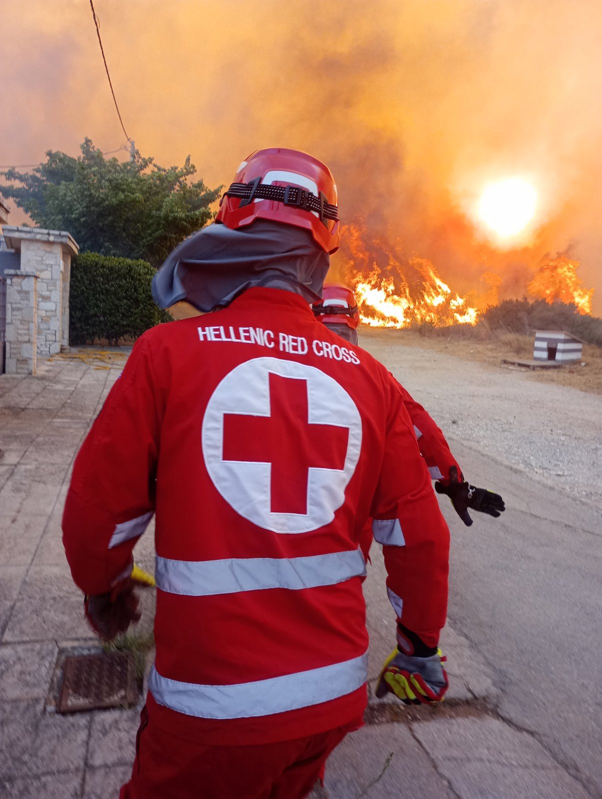
In Greece, fires swept through Attica, Crete, Evia, and Kythera in Greece, forcing the evacuation of at least 32,000,- including 5,000 tourists on Crete (IFRC, 2025; Le Monde, 2025). Tens of thousands of acres of farmland, homes, and resorts were destroyed, with half of the island of Kythera burned (Giannopoulos, 2025). At least 13 firefighters were injured, and widespread property losses disrupted daily life and tourism.
Cyprus, too, experienced its worst wildfires in decades. Intense heat, wind, and drought conditions sparked massive fires north of Limassol, leading to the tragic deaths of two people fleeing the village of Monagri. Approximately 125 square kilometers—about 1% of the island—were destroyed, forcing evacuations from 14 villages (Euronews, 2025; Reuters, 2025).
At the time of writing, the fires were still ongoing, with new major events reported in August across Greece, killing one person and leading to what was called one of the worst days of the summer (BBC, 2025). Five major fires have already burned nearly 19,800 hectares, including 7,200 hectares of the already impacted Chios island (12 August), more than 3,200 hectares around Patra (15 August), 1,500 hectares of vegetation near Lavrio in East Attica (8 August), 2,500 hectares of vegetation on Zakynthos (15 August), and over 5,200 hectares of in Preveza, Ipiros (12 August) (BBC, 2025).
To analyse whether and to what extent human-induced climate change exacerbated these conditions and what role vulnerability and exposure played in the historic event, researchers from Türkiye, Greece, the Netherlands, Sweden, Denmark, the United States and the United Kingdom undertook an attribution study on the fire weather conditions as well as the preceding dryness.
While the summer months June to August are usually the months with most fires, the fire season in the so-called biogeographic Mediterranean region, including most of Türkiye west of 38 degrees and Greece east of 17 degrees. The region has similar vegetation and fire behaviour and includes most of the affected areas.
To capture the extent and duration of the extreme fire weather across the region, we will use the cumulative daily severity rating (DSR). The DSR is a scaled power transformation of the Canadian Fire Weather Index (FWI), and reflects how difficult a fire is to suppress once ignition has occurred; it is commonly used for assessing fire weather on multi-day timescales. In addition we calculate the Vapour Pressure Deficit (VPD) which refers to the difference between the amount of moisture the air can hold and the amount it actually holds. In simple terms, it shows the drying effect on vegetation due to hot and dry air, and is a measure of acute fire weather risk. In addition to these two fireweather metrics, on 3 (DSR) and 7 (VPD) day timescales, we also analyse whether there is a trend in rainfall in the winter preceding the fire season (October to April) and whether the weather patterns at the time most fires started, of a ridge of high pressure over Greece with winds coming from the North has changed in its likelihood of occurrence.
Main Findings
- Türkiye, Greece and Cyprus are exposed to different types of wildfire events and impacts. While Türkiye and Greece face similar challenges with large-scale fires that can span multiple provinces, large summer tourist populations and fire-conducive environments, the wildland urban interface (WUI) in Turkiye is mainly in coastal tourist areas and inland forest villages, whereas in Greece the risk is particularly high in dense island settlements and in the Attica suburbs presenting different firefighting and evacuation challenges. Cyprus faces concentrated risks due to its small size and reliance on aerial support for large fires.
- Empirical weather data suggest that, in today’s climate which is warmer by 1.3°C relative to preindustrial times, the extreme conditions that drove the recent wildfires are expected to occur approximately once every 20 years. Compared to a 1.3°C cooler climate this is an increase in likelihood of about a factor of 5 and an increase in the intensity of the DSR of about 14%. Meaning the event as characterised by the DSR over the region outlined above would only be expected to occur once per 100 years without climate change.
- Looking at the observations for VPD7x gives similar results: The event in today’s climate is about a 1 in 10 year event, whereas in a 1.3°C cooler climate, it would be expected to occur once in every 100 years. The intensity has increased by about 16%.
- To determine the role of climate change in this observed trend we combine the observation-based estimates with climate models. For both indices the models on average show a stronger increase in likelihood and intensity than observed. This leads to an overall increase in VPD7x of a factor of about 13 and an increase in intensity of about 18% attributable to human-induced climate change. For DSR the overarching increase in likelihood due to climate change is a factor 10 and an increase in intensity of about 22%.
- With a further 1.3°C of global warming, causing global temperatures to reach 2.6°C, which is expected this century under current policies, the projected VPD7x conditions are 18% more intense and about six times more likely to occur, compared to now. The DSR is projected to become another 25% more intense and another nine times more likely.
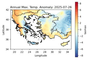
- In the winter months leading up to the wildfires, in general, it was dry in Greece and wet in Türkiye. However, across the last number of years there is an overall drying trend in both regions, with this trend stronger in Türkiye. Looking at overall rainfall observation totals during the pre-fire season, October to April, we observe these totals to have decreased by around 14%. It should be noted that the timing and duration of pre-season rainfall can act as an early indicator of potential wildfire risk, as well as the total rainfall over the period. Rainfall volume and timing can strongly affect the pre-season growth of some vegetation types, such as grasses, the amount of which can in turn affect the susceptibility to extreme wildfire.
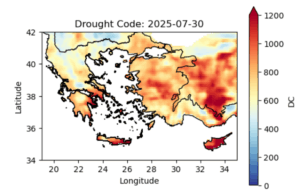
- This finding is corroborated by assessing the drought code, which is part of the Fire Weather Index used to calculate DSR. The drought code at the time of and preceding the fires showed that this was, on average, one of the driest years ever recorded.
- To analyse potential changes in weather patterns, in particular the northerly winds that made the fires spread quickly, we characterise the observed weather pattern based on the Z500 geopotential height and assess similar patterns, so called analogues over two time periods: 1951–1980 and 1994-2023. The 1951-1980 pattern shows weaker high-pressure systems and a less intense northward ridge, with a more noticeable difference between north and south. In contrast, the 1994–2023 pattern looks much more like what we saw in 2025 — with higher pressure (Z500 values) and a stronger ridge stretching further north. This change suggests that these types of high-pressure systems have become more intense, leading to more intense heat and stronger northerly winds.
- The simultaneous occurrence of highly impactful wildfires across Europe highlights the current strain on firefighting resources in the current climate with 1.3°C of warming. This year, the EU Civil Protection Mechanism, responsible for coordinating aid and support during emergencies, has been activated 17 times in response to wildfires, including in Greece, Albania, Bulgaria, and Spain over seven days. With further warming, more extreme, concurrent fire-weather will continue to challenge firefighting resources and push the limits of adaptation in some places.
- Türkiye, Greece, and Cyprus have all strengthened wildfire management and response in recent years through new technologies, expanded firefighting forces, and stricter legal frameworks. Türkiye has invested in aerial fleets, AI detection, and large volunteer networks; Greece has scaled up drones and specialized units; Cyprus has developed satellite-based detection. As climate change increases risks, adaptation efforts can be strengthened by further educating the public about wildfire risks and fire safety behaviors, increasing investment in proactive wildfire mitigation and management, and integrating Indigenous, traditional, and contemporary fire management practices into policy.


