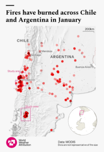
From early January 2026 severe wildfires burned through the Andean foothills of central-southern Chile and across northern Patagonia in Argentina, affecting dense native forests, national parks, and small rural and tourist communities straddling the Chile–Argentina border.
In Argentina, the fires first ignited in early January in Chubut province, then came back with force by 27 January, spreading fast through forested valleys and lake districts near Cholila, Puerto Patriada, El Hoyo, El Bolsón, and Lago Puelo and Los Alcerces National Parks. These iconic landscapes, glacial lakes, mountain towns, and peak summer tourism hubs, quickly became evacuation zones as fires advanced along the eastern slopes of the Andes (IFRC, 2026).
Across the border in Chile, fires erupted on 16 January in Biobío and Ñuble, then spread rapidly south and east through La Araucanía, Maule, and the Metropolitana region, engulfing places such as Monte Negro, Codihue, and Angol. Many of the hardest-hit communities sat directly on the wildland-urban fringe, leaving little buffer between homes and advancing flames (ECHO, 2026a).
Driven by extreme heat above 38°C, months of drought, and fierce winds of 40–50 km/h, the fires spread very fast, so intense that pyrocumulus clouds formed above some burn areas. Chile declared a state of emergency (Ministerio del Interior, 2026) when the fires destroyed at least 1,000 homes, killed 23 people, injured hundreds, and forced more than 52,000 to flee. By 23 January, over 64,000 hectares had burned nationwide. In Argentine Patagonia, a national state of emergency followed as fires consumed more than 45,000 hectares by 2 February, displacing at least 3,000 people, many of them tourists, across communities including El Hoyo, Puerto Patriada, and Epuyén (Sanchez, 2026; ECHO, 2026b).
At the time of writing, the fires were still ongoing, with new major events reported in the ancient forests of the UNESCO world heritage site Los Alerces National Park (Al Jazeera, 2026).
To analyse whether and to what extent human-induced climate change exacerbated these conditions and what role vulnerability and exposure played in the historic event, researchers from Argentina, Chile, Denmark, the Netherlands, Sweden, the United Kingdom and the United States undertook an attribution study on the fire weather conditions as well as the preceding dryness.
To capture the weather conditions that led to the outbreak and fast spread of the fires we use the hot-dry-windy index (HDWI), an index based on high wind speeds, high temperatures and low humidity. While not taking the build-up of fuel into account like other, more complex indices, it is an effective hazard metric for estimating threat to communities and difficulty of containment. We focus on two regions, in Chile the most affected region between the coast and the foothills of the Andes around the Ñuble, Biobío and La Araucanía regions [71.5W – coast; 36-38S] and a box containing the most affected region across the Chilean and Argentine border in Patagonia [41.4 – 43.4S; 70.6 – 72.6W]. For Chile we focus on the 2-day of highest HDWI and Patagonia 5-day maximum HDWI. In addition we analyse the role of human-induced climate change in the low rainfall preceding the wildfires, focussing on the same two regions and seasonal precipitation in the 3 months (November – January) preceding the outbreak.
Main Findings
- Extreme wildfire danger warnings were issued by national and regional agencies, leading to actions such as strict restrictions on the use of fire and monitoring in Argentina and alerts targeting the general public and authorities in Chile. However, limitations for example in fire monitoring which is dependent on coarse resolution, low frequency fire data, limited budget and changes to the regulation of tourism activities in Argentina may have constrained local capacity to contain the fires quickly.
- In both regions, nonnative needleleaf trees contributed to elevated wildfire risk. Monocultural pine (pinus radiata) plantations are highly flammable, due to uninterrupted similar fuel structure, dense tree stands, and species flammability. After past wildfires, fire-adapted pine has replaced native vegetation, as climate continues to increase wildfire risk – the likelihood of succession by fire adapted species and even high wildfire risk increases. Early removal of invasive pines is therefore critical to prevent landscape-scale increases in fire hazard. In Chile, these plantations were adjacent to settlements, as in the case of the similarly devastating Valparaiso fires in 2024. It is therefore key that wildfire risk is strongly accounted for in assessing and regulating current and future land use.
- Wildfires in Patagonia are destroying vast areas of native forest and grassland, putting intense pressure on wildlife found nowhere else. Vulnerable species such as the huemul and the pudú are losing critical habitat, while birds like the Patagonian black woodpecker and many native plants are left without nesting sites or viable seeds. The fires are also encroaching on Los Alerces National Park, a UNESCO World Heritage Site famous for its ancient alerce trees, some of the oldest living trees on Earth.
- To study the different variables leading to high fire danger we compute the hot dry windy index (HDWI) that combines high temperatures, high wind speeds and low humidity. Using this index, we find that the conditions that drove the wildfires in the Chilean and Patagonia regions are characterised as a 1 in 5-year event in today’s climate in both regions.
- To assess the role of climate change, we combine observation-based products and climate models and assess changes in the likelihood and intensity of a 1-in-5-year 2-day event over the Chilean region and of a 1-in-5-year 5-day event in Patagonia. In both regions the event would have been rarer in a 1.3C cooler world. In the Chile region events such as this increased in likelihood by a factor of about 3, and a factor of about 2.5 in Patagonia due to human-induced climate change.
- Both regions have experienced very low rainfall in the season preceding the fires that have a return period of 1 in 5 years in today’s climate. Combining observation-based data products and climate models we find that fire-season rainfall intensity has decreased by about 25% in the Chilean region and by about 20% in the Patagonia region. At the same time, temperatures were very high, leading to high evapotranspiration and thus dry vegetation.
- Across both regions, all climate models project a continued shift toward more severe fire weather conditions alongside declining seasonal rainfall. This strong agreement among models gives us high confidence that the changes already observed are driven by climate change.
- In addition to human-induced climate change modes of natural climate variability acting on multiple timescales during the fire season, such as La Niña and the Southern Annular Mode, promoted anticyclonic circulation anomalies that favoured the hot and dry conditions that enhanced fire persistence and severity in parts of the region.
- Ongoing wildfire risk in this region has prompted significant investment into wildfire risk management, including an operational fire risk forecasting system and an “early action protocol” by the Chilean Red Cross to anticipate wildfires based on forecasts, activating action to mitigate the potential impacts of the wildfires in the Araucanía region, including damage to houses, people being exposed to the fires, and risks associated with delayed evacuations.
- Over the last 4 years Chile has increased the budget for combating fires by 110%. These funds have been allocated to forecasting systems, equipment and fire brigades. The impacts of the January fires reinforce the need for effective spatial planning and management of tree plantations, especially at the urban-rural interface. Before new suburban development, it is key that wildfire risk is assessed for. Where existing structures exist in high risk areas, home hardening and vegetation management schemes can substantially reduce risk.


