
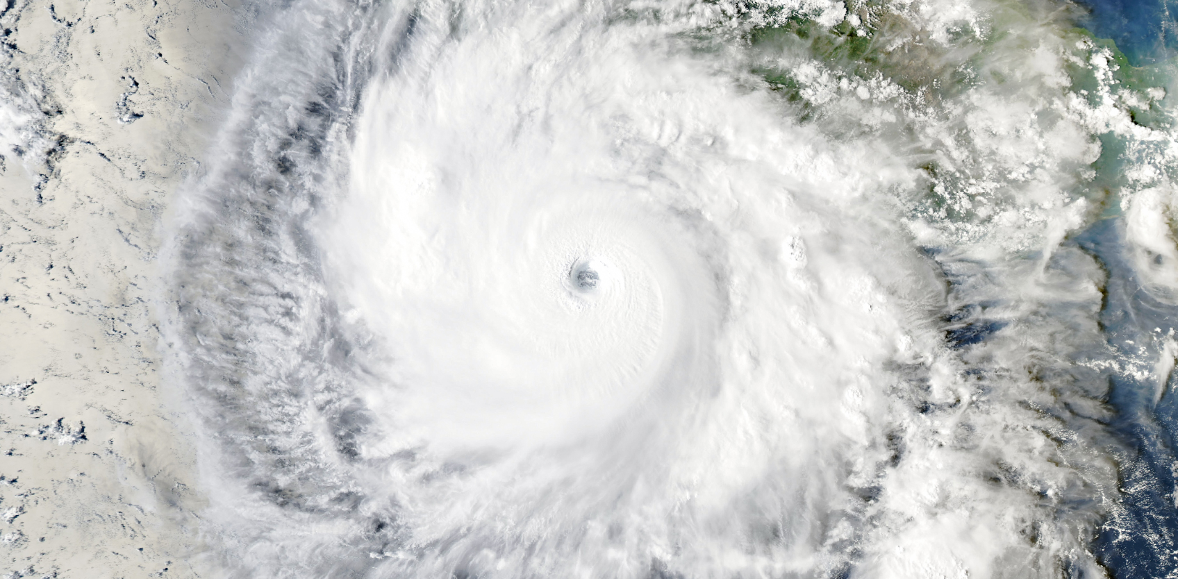
Hurricane Polo developed into a tropical depression on 20 September and rapidly strengthened into a Hurricane within 24 hours. By 22 September, the National Hurricane Center had upgraded the storm to Category 5, making it one of the fastest-strengthening storms observed in the Eastern Pacific (Copernicus, 2026). Exceptionally warm ocean waters supplied the heat and moisture needed for this rapid intensification (NASA, 2026). Polo then stalled for several days, fluctuating between Category 4 and Category 5 strength. Warmer-than-normal sea temperatures, potentially influenced by ENSO, may have contributed to its intensity (NASA, 2026a). However, the storm’s slow movement gave residents more time to prepare by securing homes and seeking shelter (BBC, 2026). Polo made landfall in Baja California Sur on 28 September as a Category 2 hurricane, before reaching mainland Mexico, east of Guaymas, on 29 September as a Category 1 hurricane (ABC News, 2026).
Despite weakening, Hurricane Polo caused flooding, fallen trees and damage to coastal communities in Baja California Sur and Sonora (PBS, 2026). Heavy rainfall and strong winds remained major threats, with forecasts warning of 100–150 mm of rainfall across southern and central Sonora and up to 200 mm in isolated areas (Reuters, 2026). Despite damage to infrastructure, power outages and disrupted communications, early warnings and preparation may have helped reduce casualties (Reuters, 2026). As of the latest reports, no fatalities have been recorded as a result of Hurricane Polo in Baja California Sur (Reuters, 2026), but four were killed in floods in Jalisco (The Rio Times, 2026) and one in Sonora (Diario de Yucatan, 2026). The remnants of Polo also brought heavy rain and flooding to parts of the United States, particularly the Southwest and Midwest. Floodwaters stranded vehicles, required helicopter rescues, damaged homes and blocked roads with water and debris. In New Mexico, around 1,000 people were evacuated due to concerns about a possible dam failure. No deaths had been reported in the United States at the time of writing.
In this study, scientists from Mexico, United States, United Kingdom, Ireland and the Netherlands, use several approaches to investigate the influence of climate change on different aspects of Hurricane Polo.
For the assessment of the role of climate change in the heavy rainfall we focus on the 1-day of the most extreme rainfall in the landfall region in which impacts were reported and which has a broadly consistent elevation and climatology, covering part of the states of Baja California Sur and Sonora in Mexico, and extending slightly into the southern US (Fig. 1, left).
To study the conditions that formed and fuelled Polo, we also analyse the role of climate change in the high sea surface temperatures that fueled the storm, and in “potential intensity” (PI), a metric that combines sea surface temperature, air temperature and air humidity data to estimate maximum hurricane wind speeds. We analyse the average September PI over the ocean between 120°W–100°W and 10°N–30°N, and, using a complementary methodology, during the days of the hurricane intensification over 110°W–95°W and 5°N–20°N (Fig. 1, right).
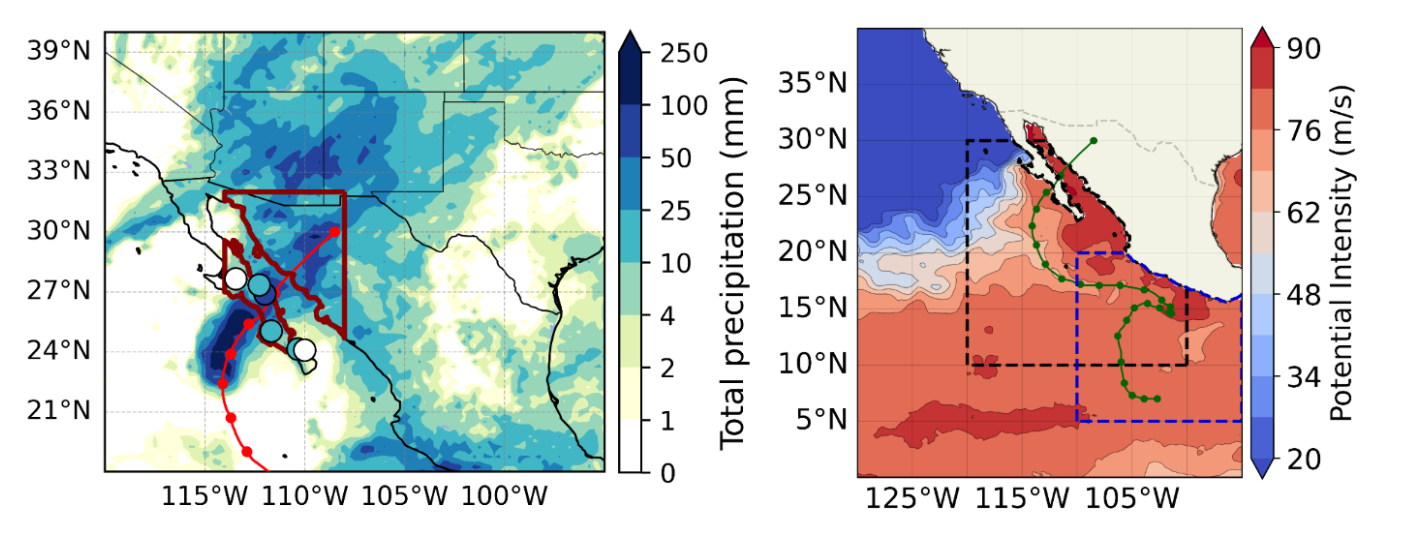
Figure 1: Left: Total precipitation on 28-29th September 2026 including ERA5 data and local weather stations with the study region outlined in dark red and the track of Hurricane Polo is shown in red. Right: September mean potential intensity in the eastern Pacific region. The study regions for the two different analyses of potential intensity are highlighted with the dashed black and blue line respectively, and the track of Hurricane Polo is shown as dark green points. Data from ERA5.
Main findings
- Hurricane Polo first made landfall as a Category 2 storm in a sparsely populated region of Baja California Sur, with fishing communities and inland villages, limiting exposure of people and infrastructure to hurricane-force winds and storm surge. By its second landfall, east of Guaymas, it had weakened to a Category 1 hurricane. Impacts were comparatively limited, with early evacuation, shelters, pre-positioned response capacity, community preparedness, and coordination across the three levels of government helping to reduce losses.
- The rainfall associated with Hurricane Polo in north-western Mexico is a common event in today’s climate, with similar rainfall totals expected approximately every two years in which there is a similar El Niño. The potential intensity conditions were less common, with a return period of around five years in today’s climate in such an El Niño state.
- To estimate if human-induced climate change influenced the heavy rainfall, we first determine if there is a trend in the observations. Observation-based datasets suggested that over the historical record, such rainfall extremes have become substantially more likely and intense as the world has warmed. Overall, the observations suggest that events like the rainfall from Hurricane Polo in the study region have become about 6 times as likely and, equivalently, such 1-in-2 year events have become about 57% wetter, albeit with very large uncertainties on these estimates. This is an extremely large increase, beyond what would be expected from the effect of a warmer atmosphere holding additional moisture. This could be due to other amplifying feedbacks with warming and dynamical shifts in rainfall patterns, but may also relate to weaknesses in the available datasets or a strong role of internal variability. Further work is required to understand all of the drivers of this trend.
- The historical observations suggested a minor connection with the concurrent ENSO conditions, with an increase in likelihood of a factor of about 1.1 to 1.4 and in intensity around 3 to 15%.
- To determine the role of climate change in the rainfall, we combine observations with climate models. We find that climate models are not able to represent the observed trends and many underestimate the extreme rainfall. This is a known problem in the region. Thus, we cannot quantify the role of climate change in the rainfall, but we highlight that the increasing trend in observations is what is expected in a warming climate according to the underlying physics.
- In addition to rainfall, we analyse the very warm sea surface temperatures (SSTs) over which Polo passed before reaching peak intensity were around 1.4°C hotter than in a preindustrial climate, or equivalently it was around 200 times as likely for such elevated SSTs to occur in this region.
- The sea surface and atmospheric conditions leading to a storm’s intensity were also studied using a metric known as potential intensity. We find that models and observations strongly agree on increases due to human-induced climate change, though observations give a much stronger trend to date. Synthesising both data sources we find that such conditions have become significantly more likely at around a factor of 23, which would make it a 1 in 115 year event without human-induced climate change. Equivalently, the potential intensity became roughly 5 m/s stronger.
- We find that the influence of El Niño is very strong, although smaller than the influence of climate change. Compared to neutral conditions, under the current July-September El Niño, the PI in September 2026 was around 14 times more likely. This suggests that it would be a 1 in 70 year event even in the present climate with neutral conditions. Equivalently, the potential intensity was roughly 4.2 m/s stronger.
- Using a complementary method to estimate the potential intensity, we also found that, the potential intensity along the track was approximately 4 m/s higher, and the actual peak wind speed of the storm was approximately 2.7 m/s higher than it would have been without human induced climate change.
- Polo left behind property damage in the Baja Peninsula and Sonora, and flooding in coastal and low-lying areas. Landslides blocked roads at several points of the federal highway showing that the impacts of a hurricane can extend far beyond its path and continue even as the storm weakens. Heavy rainfall caused flooding and mudslides in inland and dry areas, affecting communities far from where the hurricane made landfall. This highlights the importance of preparing not only for strong winds near the coast, but also for flooding and other hazards that can affect distant communities as the storm moves.
- Although early warnings and preparation helped limit Hurricane Polo’s impacts, luck also played a role, as it weakened before landfall and mainly affected sparsely populated areas. Hurricane Otis, which struck Acapulco in 2023 and caused an estimated $16 billion in damage, illustrates how impacts depend not only on storm intensity but also on where hurricanes make landfall. As the climate warms, increasingly intense hurricanes threaten more populated areas, underscoring the need for adaptation and disaster preparedness.