
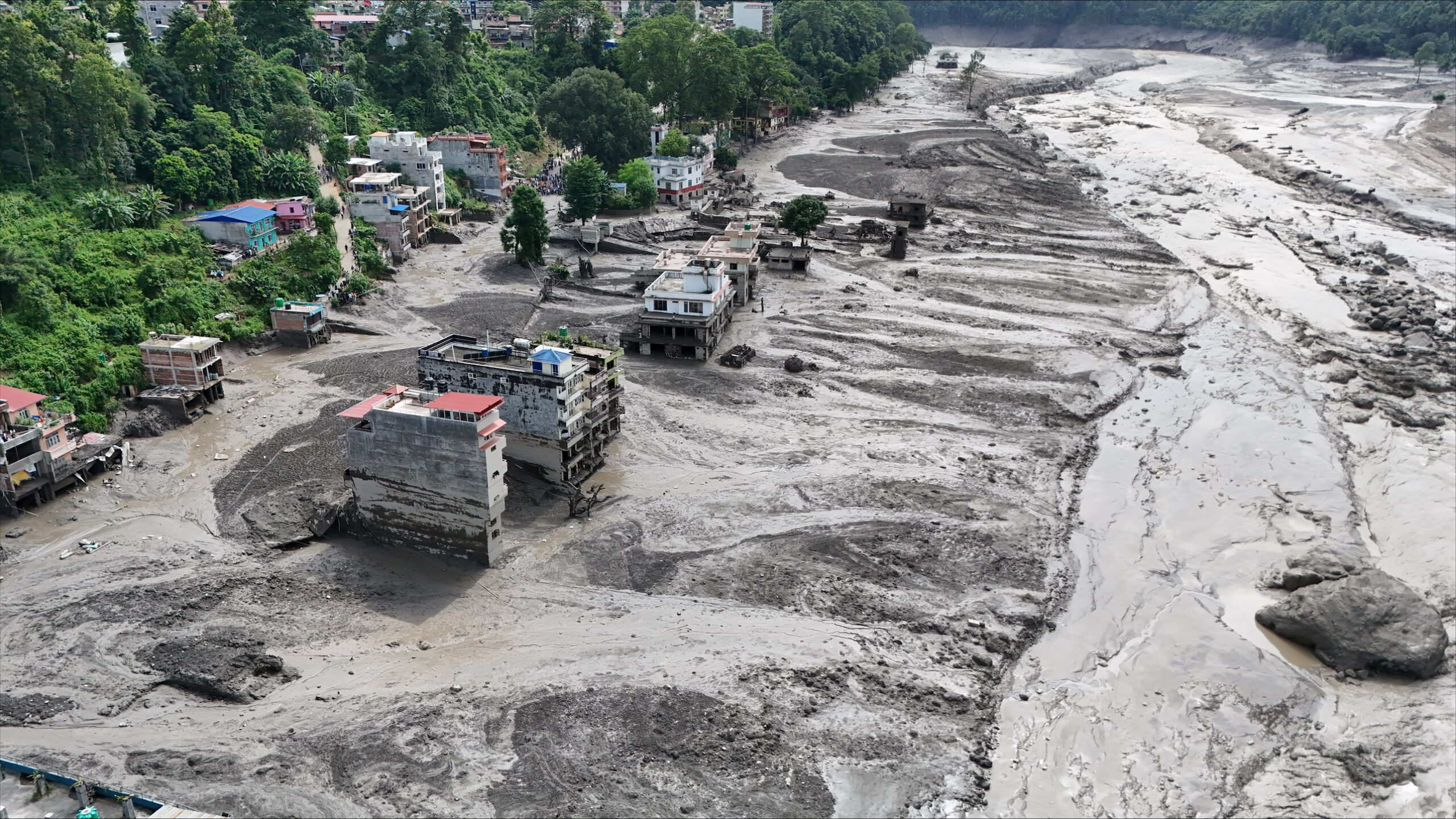
A catastrophic rock-ice avalanche that transitioned into a debris flood in the Himalayas along the Nepal–China border on 26 August 2026 has caused widespread destruction across Nepal and neighbouring regions. In Nepal, at the time of writing (14 September 2026) the disaster has resulted in over 1,300 confirmed deaths, with only a small fraction of victims identified and returned to their families. Over 5,000 people remain missing, around 13,700 people have been rescued and more than 8,600 people have received medical treatment (NDRRMA, 2026e). About 3,400 people are currently sheltering in holding centres (NDRRMA, 2026a) and an estimated 84,270 people across 17 local levels in the six districts of Rasuwa, Nuwakot, Dhading, Gorkha, Chitwan and Tanahu are affected, with the government declaring 15 municipalities as disaster crisis-hit areas for three months (UNDP, 2026a; MOHA, 2026).
While initial reports suggested that the event may have been caused by an earthquake, later evidence indicates that the recorded seismic activity was actually linked to the rapid collapse of roughly 2 square kilometers of rock wall and glacier ice (US Geological Society Earthquake Hazards Program, August 26, 2026; Center for Hydrology and Water Resources Research, 2026). The collapsing material fell approximately 1,400 m, from around 5,150 m above sea level to the valley floor at about 3,750 m. This released a huge amount of energy and produced seismic waves that were initially detected as an earthquake-like signal.
The rock-ice avalanche then triggered a series of processes. As the ice, rock and debris moved rapidly down the mountain, friction and mechanical energy probably caused some of the glacier ice to melt, producing large amounts of meltwater (Le Page, 26 August 2026 [NewScientist]). When the avalanche reached the valley floor, it also hit buried ice, which probably melted and added more water to the debris flood.
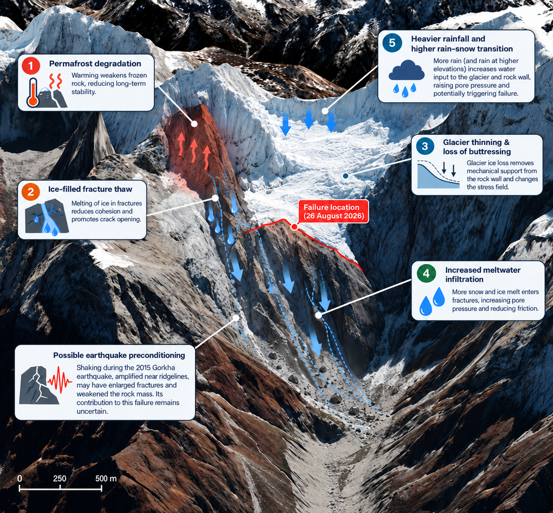
Figure 1: Climate-sensitive processes potentially contributing to failure. Conceptual representation of the main mechanisms through which climate variability and climate change may have influenced the stability of the Rasuwa rock wall.
The resulting debris flood was therefore likely caused by several sources of water, including melting glacier ice, water stored beneath the glacier and in permafrost, ice and water carried within the debris (see fig. 1), and river water pushed ahead of the flow. A wall of water, ice, rock and sediment reached the Rasuwagadhi border, 22 km downstream, within seven minutes, moving at an average speed of 188 km per hour, and wiped out the border facilities, the town of Timure and the Syabrubesi market town within the next quarter of an hour, catching pilgrims, border staff and hydropower workers (CHWRR, 2026; Lord, 2026). Within a further half hour it was in the Trishuli valley at Betrawati, and still moving boulders and pulling multi-storey buildings into the river in Betrawati and Trishuli Bazaar far downstream (CHWRR, 2026; Lord, 2026). The flood travelled 200 km to Devghat in under seven hours, where river flow more than doubled to about 5,850 cubic metres per second, and an estimated 20 million cubic meters of excess water passed in under four hours before the flood continued into India (CHWRR, 2026; Lord, 2026). The water deposited 30.5 million cubic meters of sediment and debris along the corridor, burying agricultural fields, settlements and hydropower plants (NDRRMA, 2026d).
This mixture of water, ice, rock and sediment created a highly destructive debris flood that swept away families, homes, settlements, roads, bridges and other infrastructure along the corridor, leaving survivors stranded and cut off, many having also lost family members and everything they owned more than 35 km downstream while the water travelled much further, at Glachi, 88 km downstream the water level of the river Trishuli rose by 8.5m (Center for Land Surface Hazards, 2026). The extent of the humanitarian catastrophe is still being assessed.
Researchers from Nepal, Pakistan, the UK, Ireland, Sweden, Denmark, Norway, the US, New Zealand and the Netherlands, including experts in glaciology, mountain hydrology, climate science, humanitarian aid, seismology and social science, have come together to examine the range of factors that may have contributed to this event. While the underlying geological structure controlled where and how the slope failed, longer-term warming and changing precipitation phase from snow to rain may have reduced its stability by weakening ice-filled fractures and rock–ice contacts and increasing water pressure. Climate change is thus best understood as a destabilising factor acting on a pre-existing geological predisposition, rather than the fundamental cause of the failure. Therefore, rather than conducting a conventional attribution study which is typically focused on a single, well-defined weather event, we are bringing together the available scientific knowledge on known and potential drivers, while also investigating how these drivers have changed in a warming climate.
Main Findings
- Nepal has established early warning systems and adaptation measures that can help reduce impacts from more conventional and forecastable riverine floods, and have demonstrably helped save lives, including among communities downstream. However, the event was fundamentally different in its magnitude, speed and complexity. It was beyond the design and predictive limits of existing risk reduction measures, and no existing early warning system could have provided sufficient lead time or prevented the scale of impacts observed in the worst-affected areas, highlighting the limits of adaptation. In a rapidly warming Himalaya, increasingly extreme and complex hazards are exceeding adaptation capacity, resulting in loss and damage. This is occurring against a baseline of a high frequency of large earthquakes, which both destabilises slopes and hampers recovery from successive disasters.
- The immediate impacts of this cascading hazard were almost entirely dependent on exposure to hazard, whereas longer-term impacts (e.g. related to recovery, long-term health effects) are likely to vary based on socioeconomic vulnerability characteristics of the populations affected. In a high mountain context where habitable land is constrained, population is increasing, and economic activity is dependent on rivers, it would be very socially, economically and politically difficult to eliminate or even substantially reduce exposure in riverine valleys, representing a soft limit to adaptation.
- The 26 August 2026 Rasuwa disaster was triggered by a large rock wall collapse from the Langtang Lirung mountain at 5,150 m asl., which also caused part of the overlying glacier to collapse. The resulting rock–ice avalanche rapidly transformed into a debris flood and then a water-dominated flash flood that traveled downstream at average speeds of 188 km/hr, causing extensive erosion and sediment deposition. The failure involved an exceptionally large volume of rock and ice that on impact with the ground released energy equivalent to a M5.5 earthquake. There are several possible contributing causes, as outlined in the following points.
- In 2015 an earthquake of magnitude 7.8 triggered a catastrophic rock–ice avalanche at Langtang Lirung and caused widespread damage across the region. Subsequent monitoring shows persistently elevated and, at high elevations, increased landslide activity, suggesting that earthquake shaking may have weakened the underlying rock mass over the long term. Although its specific contribution to the 2026 failure cannot yet be confirmed, the earthquake may have preconditioned the slope for failure, alongside geological and climatic factors.
- Warming and permafrost degradation likely weakened the source rock wall by increasing bedrock temperatures and thawing ice within fractures. Loss of ice bonding reduces fracture strength, while meltwater can increase water pressure and further destabilise pre-existing geological weaknesses. Thus, permafrost degradation may have acted as an additional climate-related factor preconditioning the slope for failure.
- Glaciers in the region have been losing mass for decades at a rate equivalent to more than half a metre of thinning per year. Since 2010 the rate of recession of the Langtang-Lirung glacier extent has accelerated, increasing from 0.5% per annum over the previous two centuries to 1-2.3% per annum in the past 16 years. Glacier thinning and retreat can reduce buttressing and alter stresses within adjacent rock walls, potentially weakening existing fractures and increasing slope instability. Combined with increased meltwater, these processes may have interacted to amplify the compound event.
- Precipitation can provide an additional short-timescale forcing. As temperatures rise, the rain–snow transition moves upward, increasing the fraction of rain falling as snow at higher elevations. Rain produces an immediate liquid-water input to the slope, whereas snowfall temporarily stores water at the surface. Intense or prolonged rainfall can therefore rapidly increase water supply to fractures and potentially increase fracture-water pressure. At the rock-ice-avalanche location, stations recorded exceptionally high precipitation during October 2025, which combined with subsequent warmth may have been a source for meltwater during the following spring and monsoon seasons. There is also a tendency of the greater fraction of precipitation falling as rain than snow in recent years. This means there can be an increase in the amount of water stored in the land under the avalanche site, even in the absence of anomalously high total precipitation.
- Observations show unusually warm conditions before the failure, supporting enhanced snow and ice melt and more precipitation falling as rain rather than snow. The slope failure on August 26th occurred against the backdrop of a warm 12 month period from September 2025-August 2026, with the warmest two months of the year (July and August) directly preceding the event also substantially warmer than the climatological average. These conditions were anomalous at the location of the slope failure itself and across the wider Himalayan region.
- We also analysed the height of the 0°C isotherm, finding that it has shifted to higher elevations consistent with global warming, with particularly strong trends observed during the Monsoon and Postmonsoon seasons. This progressive upward retreat of the freezing threshold is on the order of 100m/decade in recent decades in the Monsoon and Postmonsoon season. This is highly relevant as it can contribute to the degradation of high-elevation permafrost, glacial thinning and retreat, the snowfall-rainfall transition, and associated slope instability.
- When analysing how these conditions were different in a 1.4°C cooler preindustrial climate, using the standard WWA attribution framework that compares possible weather in today’s climate with possible weather in a 1.4°C cooler preindustrial climate using climate models and statistical models based on weather observations. We find in all datasets a significant increase in the likelihood and intensity of the very warm July-August temperatures at the gridcell nearest to the slope failure as well as in the wider region with an increase in temperature attributable to human-caused climate change during July and August of about 1.5°C, comparable to the level of global warming. Annually, the attributable increase is larger than global warming, at about 2°C. In individual winter months, the observed increase is as high as 3°C.
- We have not assessed whether this specific rock-ice avalanche would have occurred in the absence of human-induced climate change. Such a direct attribution requires additional evidence linking atmospheric conditions to subsurface temperatures, fracture-water pressures and the mechanical evolution of the slope. However, rapidly rising temperatures at a rate beyond the global mean as a result of fossil fuel emissions increase the likelihood and severity of such hazards in the Himalayas.
- Significant progress in adaptation is needed, particularly through strengthened high Himalaya earth observation, hazard monitoring, risk communication and transboundary data and knowledge sharing. But events of this magnitude ultimately exceed the limits of adaptation. Addressing unfolding and imminent loss and damage, through recovery and reconstruction support in impacted communities, has now become an unavoidable part of climate response.
- Minimising future risk requires a rapid transition away from fossil fuel use and delivering on climate finance commitments for adaptation. This is particularly important in the Himalaya and other high mountains, where glacier decline and permafrost degradation are expected to continue even without further warming, meaning that some of the impacts of past warming have yet to fully emerge.