
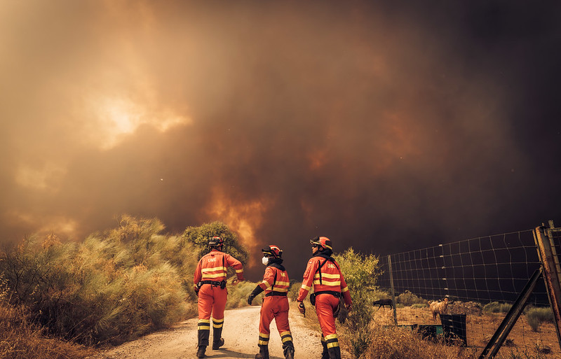
After months of drought (WWA, 2026a) and periods of extreme heat (WWA, 2026b), Western Europe is battling widespread and intense wildfires. At the time of writing (July 30th 2026) the most severe fires are affecting southwestern France and central and eastern Spain. Firefighters in both countries have been supported by aircraft and emergency personnel deployed through the European Union Civil Protection Mechanism as authorities work to contain the blazes (European Commission, 2026).
In France, the fires originated near the Atlantic coast on 22 and 23 July but have since spread inland, becoming particularly destructive in the Gironde department around Bordeaux. The Gironde fire has so far burned approximately 40,000 ha, the second largest area of land devastated by a single wildfire in France since the Second World War (Reuters, 2026; Guardian, 2026). This region includes a large expanse of man-made woodland, dominated by > 800,000 ha of intensively managed maritime pine monocultures (Mora et al 2012). The fuel structure of these high-density plantations included abundant needle-leaf litter, ‘ladder fuels’ connecting the ground and canopy, volatile oils supporting flashy combustion and connected canopies allowing canopy fire (known as crown fire). This meant the fires could spread very rapidly (International Fire and Safety Journal, July 27, 2026; CBC News July 29, 2026; Fernandes and Rigolot, 2007). The fire generated a pyrocumulonimbus, or fire-driven thunderstorm, creating abundant lightning and high winds that exacerbated the speed of fire propagation. At least 240 homes have been destroyed, with many more damaged, while around 220,000 residents and tourists were evacuated as the fires continue to threaten forests, highly touristic and iconic areas, as well as sensitive economic activities and surrounding communities (The Guardian, 2026). The French Minister of the Interior, Laurent Nuñez, declared on 26 July that a record area of around 115,000 ha had burned in France since the beginning of the year (NY Times, 2026).
In Spain, between 13 and 28 July 2026, around 140,000 ha were burnt, mainly as a result of three major fires: Ávila–Madrid–Toledo (central Spain, west of Madrid); Guadalajara (central Spain, northeast of Madrid); and Castellón (east Spain). The fire in Ávila, which was ignited following negligent use of heavy machinery (El Mundo, 2026) and has burnt 44,000 ha, is now “the largest and most destructive fire in Spain’s history”, in the words of the Minister of the Interior, Fernando Grande-Marlaska (RTVE, 2026), while the fires in La Mierla (province of Guadalajara) have burnt 35,000 ha, making it the third worst fire in Spain’s recent history (RTVE, 2026). As of July 28th, the fires have led to more than 80,000 people being evacuated and nearly 100,000 being advised to stay indoors due to poor air quality (El País, 2026).
In Spain, January 2026 was the wettest January of the last quarter of a century (AEMET, 2026). In particular, in the area affected by the Ávila–Madrid–Toledo fire, rainfall was 175% higher than usual, which allowed a great accumulation of plant biomass. The summer of 2026 began with record-breaking temperatures and a severe drought, both conditions exacerbated by human-caused climate change (WWA, 2026a; WWA, 2026b). This sequence resulted in high fuel loads that then dried to become highly flammable, increasing the intensity of the fires. According to the State Meteorological Agency (AEMET), this summer is proving to be the hottest on record in Spain (RTVE, 2026). While temperatures dipped slightly from the 19th of July, France declared another heatwave commencing the 29th of July (Meteo France, 2026), and further heat and dry conditions are expected in the coming days in both France and Spain (ECMWF, 2026). The combination of extreme heat and wildfire smoke has been shown to be particularly dangerous to human health (Chen et al., 2024, White, 2024), and makes the work of the firefighters even more dangerous and difficult.
In 2025, WWA conducted two rapid attribution studies on fires in Spain and Portugal (WWA, 2025a) and Turkiye, Cyprus and Greece (WWA, 2025b), alongside a retrospective analysis of the entire wildfire season in several European regions (Keeping et al., 2026b). Across all three studies, we found that human-caused climate change was a key driver of the fire weather conditions, primarily through its influence on exceptionally high temperatures, but also by exacerbating drought conditions. In addition, our analysis of the affected regions in Spain identified the role of “weather whiplash”, a pattern of unusually wet springs followed by hot, dry summers which promotes abundant vegetation growth that subsequently dries out, creating large amounts of highly flammable fuel and increasing wildfire risk. Keeping et al. (2026b) found that in northwestern Iberia and southwestern France, the likelihood of wet springs is probably not decreasing, but that the chance of very dry summers is increasing strongly. This phenomenon has also been found in other fire regimes (Swain et al., 2025).
Following the detailed assessment from Keeping et al., (2026b), we perform a super rapid analysis of trends in fire-conducive weather conditions in the two affected areas in France and Spain, analysing observations only. To capture the extent and duration of the extreme fire weather across the region, we use the cumulative Daily Severity Rating (DSR). The DSR is a scaled power transformation of the Canadian Fire Weather Index (FWI), and reflects how difficult a fire is to suppress once ignition has occurred; it is commonly used for assessing fire weather on multi-day timescales. Both indices (FWI and DSR) have been used extensively to characterize fire weather in Western Europe (e.g. Calheiros et al., 2020; Silva et al., 2023). Here we focus on the DSR for the 7 days of most intense fire weather conditions (henceforth DSR7x) in the regions of the worst fires in southwestern France (Gironde and Landes) and central Spain (Toledo, Ávila, Madrid and Guadalajara); Fig. 1.
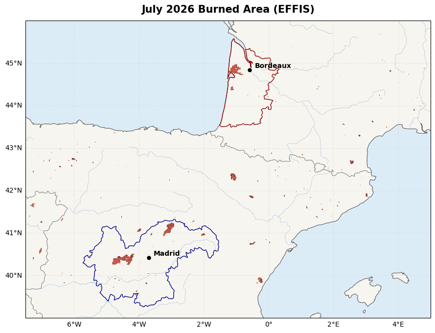
Figure 1: Burned area in July over central Spain and southwestern France from July 1st-27th. Data source: European Forest Fire Information System (EFFIS) burnt areas database. The southwestern France study region (Gironde and Landes) is outlined in dark red, and central Spain (Toledo, Ávila, Madrid and Guadalajara) in dark blue.
Key Messages
- The recent fires in France and Spain had particularly large impacts as extreme fire weather conditions coincided with high exposure. In France, the fires quickly propagated close to densely populated areas and major tourist destinations, requiring large-scale evacuations and exposing an increasingly urbanized region to both the fires and widespread smoke.
- Very large amounts of pollutants were released by the fires. In France, particulate matter in the nearby city of Bordeaux exceeded the level considered as “fair” air quality by a factor of 20, and extremely poor conditions were felt as far as 400 kilometres away. This led to the release and dissemination of the strategic national reserve of FFP2 masks to local pharmacies. Such hazardous air pollution contributes to an accumulation of detrimental conditions for a population already hit hard by repeated heatwaves since May.
- The weeks leading up to the fires were characterised by a succession of extreme heatwaves and low rainfall across much of Western Europe, despite it still being comparably early in the season. Recent studies have shown human-caused climate change increased the likelihood of these hot and dry antecedent conditions, which were essential for the development of the extreme fire weather that enabled the fires.
- Conditions associated with a seven-day Daily Severity Rating (DSR7x) of the observed magnitude are much less common in southwest France than in central Spain in today’s climate. An event of this intensity is expected about once every 20 years in southwest France, compared with about once every 6 years in central Spain.
- In both study regions observations show strong trends of increasing likelihood and severity with global warming. DSR7x values as extreme as those observed in central Spain in July 2026 are now at least 20 times more likely than in a pre-industrial climate. In the French regions the statistical model fits the data less closely and may underestimate the return period of the event, thus the result of an increase in likelihood by at least a factor two in southwest France is a conservative estimate.
- Above-average winter rainfall led to high soil-moisture and promoted vegetation growth. This was followed by anomalously dry and warm conditions that depleted soil moisture, particularly at the surface, which is critical for drying grasses and other fine fuels. In addition, the dryness and heat increased water stress in native vegetation including shrubs and pine trees. Together, these conditions exacerbated the likelihood of fire ignition and rapid fire spread by providing more readily available fuel.
- The wet-winter to dry-spring transition is an increasingly important driver of wildfire risk in western Europe. A recent attribution study has shown that climate change is increasing the likelihood of severe soil moisture drought through higher atmospheric evaporative demand, while the same sequence of above-average winter rainfall followed by exceptional spring drying was identified as a key driver of the 2025 Iberian wildfires.
- Severe fire weather is no longer rare under today’s climate. As the likelihood of these compound fire weather conditions continues to increase, reducing wildfire risk will require not only effective fire suppression and cross-border coordination, but also greater emphasis on prevention through risk-sensitive landscape planning and management (e.g., increasing species diversity) and reducing exposure.
- While accelerated adaptation is crucial, there are also limits to adaptation. Limiting further increases in fire risk requires a rapid transition away from fossil fuels.
Hazard analysis
Antecedent weather conditions
Figure 2 shows the time series of daily maximum temperatures and precipitation averaged over the two study regions, along with the daily severity rating (DSR). Heatwave events are highlighted in yellow, with spikes in DSR tending to occur toward the end of these periods of extreme heat. An unusually early heatwave saw May temperature records broken across western Europe, and was followed in late June by a second record-breaking event, with extreme temperatures persisting from June 17th-30th. In France, June 2026 was the hottest June since records began, with the heatwave exceeding the previous record high in August 2003. Such high temperatures were found to have been tens to hundreds of times more likely to occur in 2026 than they would have been in 2003, due to anthropogenic warming (Keeping et al., 2026a). A third heatwave followed from July 4-19 (Meteo France, 2026a), and at the time of writing, a fourth has been forecast for the end of July (Meteo France, 2026b). At the same time, following a relatively wet January and February and a dry spring, rainfall during the summer months of June and July was extremely low. In combination with the persistently high summer temperatures, which induced a strong drying effect through potential evapotranspiration, this led to drought conditions across much of Europe, also largely driven by human-caused warming (Kew at al., 2026). The compounding effect of the succession of heatwaves, in combination with the dry spring and summer, is to increase the DSR – representing the wildfire risk – beyond what would be expected for the time of year (see Figures A2.1 and A2.2 in the Appendix for plots of DSR, daily maximum temperatures and daily precipitation against 1990-2025 climatology).
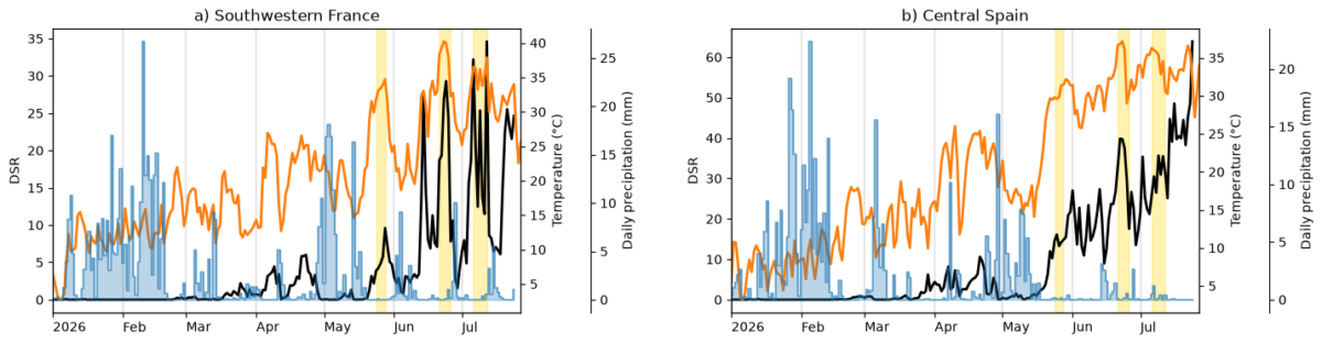
Figure 2: Daily severity rating (DSR, black), daily maximum temperatures (orange) and daily precipitation (blue) over (a) southwestern France and (b) central Spain. Yellow bands represent heatwave events. DSR data from CEMS, temperature and precipitation data from ERA5.
Observed trends in DSR
To understand the changing risk of extreme wildfires like those observed in southwestern France and central Spain in July 2026, we analyse changes in the overall fire weather conditions in those regions, and the long spell of extreme temperatures that contributed to those conditions. We characterise the fire weather conditions using the DSR (Daily Severity Rating), a rescaling of the Canadian Fire Weather Index (FWI) intended to capture the overall impact of meteorological conditions on the likely wildfire hazard in an ecologically similar region. The FWI accounts for long term precipitation and evapotranspiration conditions in the build up of dry fuels – separately modelling the moisture response of heavy fuels such as logs, mid-sized twigs and buried organic matter, and fine fuels such as pine needles. These fuel conditions are then combined with daily heat, humidity and wind to estimate the likely severity of a wildfire, were an ignition to be successful. The DSR combines FWI conditions across the landscape, weighting extreme values more highly to capture the overall difficulty in suppressing wildfires over the wider region and multiple days. The FWI and DSR are widely adopted across Europe to characterise fire risk, including by the European Forest Fire Information System (EFFIS). For the temperature trend, maximum daily temperatures are examined – as these extreme values drive the short term atmospheric drying demand, causing extremely dry fine fuels. As the fires occurred during the peak of the summer wildfire season, we compare this year’s conditions to the maximum fire weather and temperature conditions in all previous summers (June-August). We examined the annual maximum 7-day accumulated DSR (DSR7x) over the two regions, corresponding to the peak week of fire weather during the period.
To analyse trends in aspects of the weather associated with fire-prone conditions, we follow the World Weather Attribution protocol (Philip et al., 2020) for observations only. For each time series we estimate the parameters of a statistical model in which the index depends on the global mean surface temperature (GMST). A nonstationary generalised extreme value (GEV) distribution is used to model the 7-day fire weather conditions (DSR7x) in each region. In each case, the distribution is assumed to shift linearly with the GMST covariate, while the variance remains constant. The parameters of the statistical model are estimated using maximum likelihood. This model is then used to estimate the return period and intensity of the event under study for the 2026 GMST and for a 1.4°C cooler counterfactual climate representing a world without human-caused warming (based on Forster et al., 2026). This allows us to compare the expected intensity and frequency of similar events now and in the preindustrial past, by calculating the probability ratio (PR; the factor-change in the event’s probability) and change in intensity of the event.
At the time of writing, the DSR7x in southwest France occurred from July 6th-12th, about two weeks before the initial outbreak of the wildfires, although the DSR subsequently reached a slightly lower (but still high) peak at the time of the fires. The maximum DSR over this region has a return period of around 22 years; unusual, but not particularly extreme in the current climate (Table 1). DSR7x intensity in this area has increased by around 46% as a result of anthropogenic climate change; similar conditions are now at least twice as likely as they would have been in a world without human-caused warming and at least 40% more likely than they would have been in 2000. Figure 3 shows the time series of annual peak 7-day DSR, along with the fitted model (panels a-b). While the underlying trend is well represented by the model (indicated by the black line, represented the fitted values, running parallel to the green line, a nonparametric smoother through the data), the shape of the distribution may not be well captured (indicated by the relatively poor fit of the points to the line in panel c); it is possible that the return period of the event is underestimated in both the factual and counterfactual climates, and that the probability ratio is therefore a conservative estimate.
In central Spain, the peak 7-day DSR occurred on July 24th, the last day for which data was available at the time of writing; it is possible that even higher values will be reached on subsequent days. This event was relatively commonplace, with a return period of around 6 years in the current climate. DSR7x has increased by around 42% compared to a 1.4°C cooler world without human-caused warming, and as a result, similarly high DSR7x values have become at least twenty times more likely than they would have been in a preindustrial climate, and at least three times more likely than they would have been in 2000. Figure 4 shows the fitted model; in this case, both the underlying trend and the shape of the distribution are well represented by the model, suggesting that the results are more robust.
| Event Magnitude | Return Period(years) | Change since preindustrial | Change since 2000 | |||
| Change in intensity(%) | Probability Ratio | Change in intensity(%) | Probability Ratio | |||
| SW France | 21.5 | 21.9(9.99 – 68.2) | 45.8(24.1 – 92.7) | 7.37(2.07 – Inf) | 15.6(9.06 – 26) | 2.37(1.39 – 17.9) |
| C. Spain | 45.8 | 6.44(3.36 – 23.5) | 41.8(21.6 – 72.6) | 780(22.2 – Inf) | 14.4(8.23 – 22) | 5.69(3.17 – Inf) |
Table 1: Return period and magnitudes of the 7-day DSR in each of the two study regions, along with the relative change in intensity and probability ratio (factor change in the likelihood of similarly extreme events) associated with a 1.4°C increase in global mean surface temperature (GMST) since the preindustrial period, and 0.6°C increase in GMST since 2000. Bootstrapped uncertainties are given in parentheses.
Figure 3: (a) DSR7x in SW France with fitted model overlaid. Solid black line denotes the expected peak DSR7x each year; blue lines indicate the expected magnitude each year of a 1-in-6-year (thick line) and 1-in-40-year DSR7x event (thin line). Green dashed line is a nonparametric Loess smoother. 2026 event is shown with a pink dot. (b) Same as a, but plotted against GMST. (c) Expected return levels of DSR7x over SW France: in the 2026 climate (red lines) and in a 1.4°C cooler counterfactual climate (blue line). Shaded regions represent 95% confidence intervals obtained via a bootstrapping procedure. The pink line shows the peak DSR7x in 2026 (at the time of writing). Red and blue ticks at the x axis indicate the estimated return level of the event in the 2026 climate and counterfactual climates.
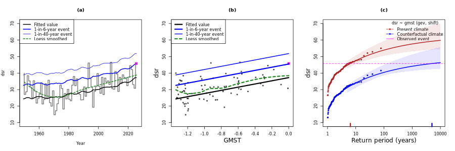
Figure 4: As Figure 3, but for the Central Spain region.
Soil moisture analysis
Figure 5 shows the surface soil moisture (from the surface to a depth of 7 cm) and root zone soil moisture (from the surface to a depth of 100 cm) anomalies over the wider region during winter (DJF 2025/26), spring (MAM 2026) and summer (JJA 2026). Despite the above-average winter rainfall, both France and Spain experienced anomalously low surface soil moisture during spring, with deficits persisting into summer. This is the key variable from a fire risk perspective, as it is driven by the same evaporative and wetting effects (in addition to drainage) controlling dead fuel moisture, and is therefore often used as a proxy for fuel moisture. Low surface soil moisture during spring can also relate to vegetation stress for grasses and in shallow soil environments – though that is likely not a major factor for these fire events. We also show root zone soil moisture, where the favourable winter/early-spring growing conditions are apparent for both regions. A minor dry anomaly in the root zone is shown over France this summer, which may have had some effect on the forest’s vulnerability to fire.
This combination of fuel growth and biomass availability due to the winter rains, along with the heat and drying during the succession of heatwaves throughout spring and summer, may have contributed to favourable conditions for wildfire ignition and spread this season. A similar progression from a wet winter to dry spring and summer was linked to the extreme Iberian wildfires of 2025 (Keeping et al., 2026b). The persistent soil moisture deficits across the wider region used in this study have been analysed in a recent rapid attribution study on the ongoing European drought (WWA, 2026a), which concluded that the likelihood of severe soil moisture drought across western Europe is linked to increases in atmospheric evaporative demand due to global warming. These findings reinforce the role of warming-driven soil moisture depletion in increasing wildfire risk, even following winters with above-average rainfall.
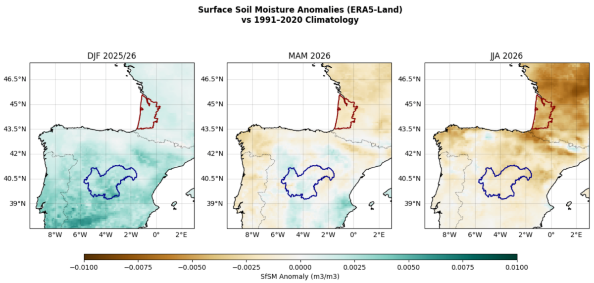
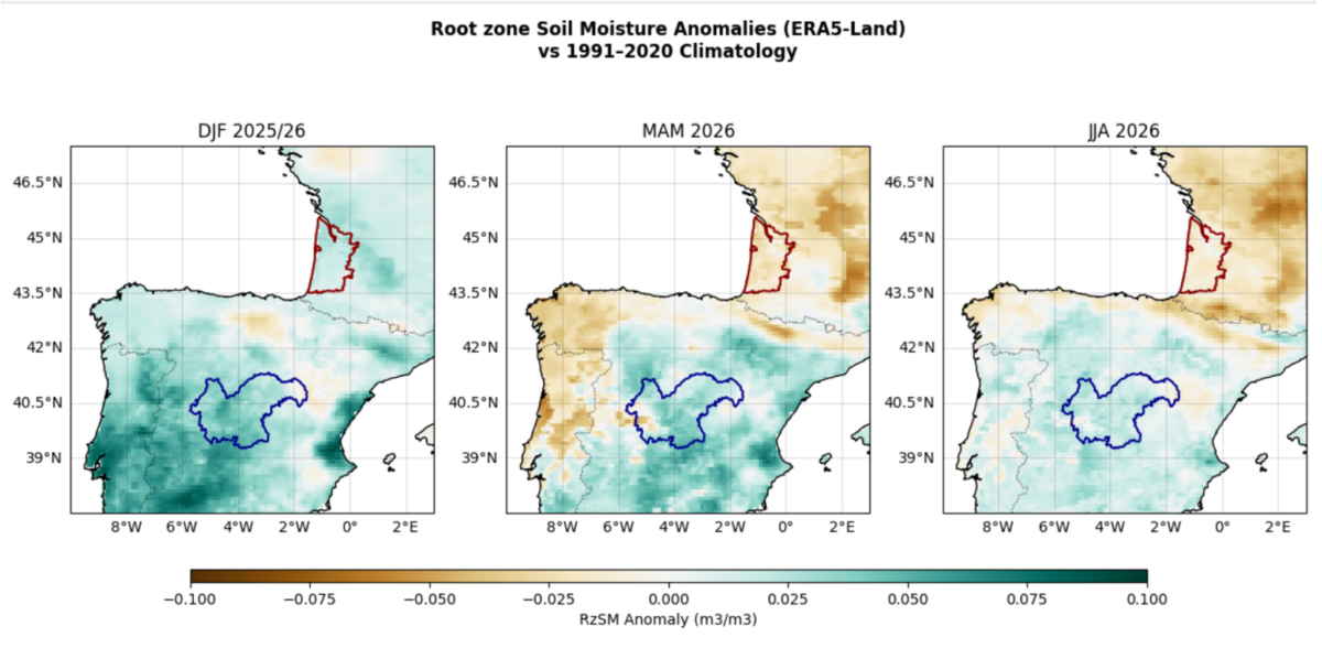
Figure 5: Top: ERA5-Land surface soil moisture anomaly with respect to years 1991-2020 for Dec-Feb 2025/26 (top left), March-May 2026 (top centre) and June-August 2026 (top right). Note that the 2026 JJA season is ongoing at the time of writing, so the averaging is carried out for June 1 – July 27 2026. Bottom: same as above, but for root zone soil moisture.
Existing literature on fire weather in western Europe
The number of extreme fire weather days (FWI95d using ERA5) has shown clear upward trends since the 1950s across western Europe (Portugal, Spain and France), with the most affected areas gaining five extra days of extreme fire weather per decade (Bayar et al., 2026). Consistent upward FWI trends have been found across Europe in bias-corrected global climate models (Hetzer et al., 2024). Increasing trends in fire weather season length have also been pronounced in Europe (Jones et al., 2022), meaning that the time window of conditions conducive to fire is expanding. However, the increase in fire weather has not been linear, with recent decades showing a steeper rise in extreme fire weather days than earlier periods and extremes now occurring outside the typical fire weather season (Giannaros and Papavasileiou, 2023, Ramos et al., 2023).
These upward trends in fire weather in western Europe contrast with trends in burned areas. Fire activity in Mediterranean Europe, measured by the Burned Area (BA) aggregated over seasons and regions, is strongly linked to hot and dry climatic conditions (e.g., Gincheva et al., 2024; Russo et al., 2017; Turco et al., 2017; Vissio et al., 2023). However, despite the intensification of these climatic conditions in recent years (IPCC, 2021), fire activity has not followed the expected trend based solely on climate (Fréjaville & Curt, 2017; Turco et al., 2014). Several studies have demonstrated a reduction in BA in countries such as Italy, Spain (Silva et al., 2019; Turco et al., 2013; Urbieta et al., 2019), and southern France (Fréjaville & Curt, 2017), with more heterogeneous results in Portugal (Oliveira et al., 2011; Turco et al., 2019a). A previous study, (Turco et al., 2016) reported an approximate 66% reduction in BA between 1985 and 2011 for the entire Mediterranean Europe. These opposing trends between climatic drivers and BA suggest that different factors operate on different timescales. Specifically, the negative trend in BA over the past few decades can be attributed to increased efforts in fire management and prevention. Yet, unexpected high-impact wildfire events exceeding the firefighting capacity are still emerging, in part because this same aggressive suppression allows fuels to accumulate, so that when ignition sources and extreme favorable weather conditions occur, fires escape control.
Across Europe, extreme fire weather days have not only become more common in recent years, but also more synchronized (Torres-Vázquez et al., 2025; Miller et al., 2026; Gauthier and Bevacqua 2026, Yin et al., 2026). When multiple regions are simultaneously affected by wildfires, the EU’s mutual-aid capacity is overwhelmed, reducing the cross-border sharing of firefighting resources and further enhancing the impacts.
Future projections of FWI across various studies agree that European fire weather will become more frequent, more intense, and more widespread with increasing global warming (Bayar et al., 2026; Hetzer et al., 2024; El Garroussi et al., 2024; Bento et al., 2023, Jones et al., 2022). Regional results suggest that future rising FWI across France and Iberia may result from an increased surface layer dryness or stronger winds (Bayar et al., 2026). Under 3°C of global warming, the magnitude of extreme fire weather metrics in Europe nearly doubles relative to 2°C, but even at 2°C the impacts are far from negligible (Bevacqua et al., 2026).
Potential increases in BA due to further increases in dry and hot conditions over Mediterranean Europe could overwhelm current fire prevention efforts, implying that more robust fire management strategies are needed in the near future. For instance, considering only future changes in climate projections, BA in the Mediterranean is projected to increase by 40% to 100% under warming scenarios of 1.5°C to 3°C (Turco et al., 2018). In line with this, a recent study found a significant shift in the relationship linking fire weather conditions and fire intensity across European IPCC regions, suggesting that global warming may be inducing an emerging change in regional fire dynamics towards increased fire impacts in Europe (Carnicer et al., 2022).
Hazard conclusions
The late spring and summer of 2026 in western Europe have been characterised by a succession of extreme heatwaves and unusually low rainfall, creating tinderbox conditions.
Analysis of historical trends in annual maxima of the 7-day accumulated Daily Severity Rating (DSR) shows that similarly severe wildfire conditions would be expected around once every 20 years in southwest France, and around once every 6 years in central Spain. In both regions, the likelihood and severity of the 7-day DSR have been increased by human-caused warming; similarly extreme values are now at least twice as likely in southwestern France and at least 20 times as likely in central Spain.
Following a relatively wet winter, both surface and root zone soil moisture have decreased throughout the year in both regions, reflecting the strong drying conditions that contributed to the high fire risk.
An extensive body of existing literature shows an expected increase in the severity of fire weather as the world warms, both historically and in response to projected future warming. Historic burned area trends do not reflect this, with reductions in average burned area over recent decades due to increased efforts in fire management and prevention. However, the risk of unexpected high-impact wildfire events exceeding available firefighting capacity is still emerging, particularly with the increasing likelihood of multiple large wildfires occurring simultaneously across Europe.
The evidence presented here and in previous studies shows that human-caused climate change substantially increased the likelihood of the hot, dry antecedent conditions, extreme fire weather, and severe soil moisture deficits that together created the exceptional wildfire hazard observed in July 2026. The increasing frequency and intensity of these conditions demonstrate that such wildfire-conducive environments are becoming increasingly common across Western Europe with global warming.
Vulnerability and Exposure
The majority of fires in the Mediterranean region have human ignition sources (Ganteaume, 2012). Wildfire exposure is determined by the degree to which settlements expand into the Wildland-Urban Interface (WUI), increasing their risk. Research in Catalonia found that human exposure per unit of burned area increased by between 42% and 138% from 1992 to 2021, depending on the dataset and distance from fire perimeters (Torres-Vázquez et al., 2026). Demographic redistribution and land-use change accounted for as much as 79% of the increase, particularly in coastal and peri-urban areas similar to those in the current fires (Torres-Vázquez et al., 2026). The populations in both the Landes and Gironde regions have increased steadily over the last few decades, especially around the metropolitan areas of Bordeaux (CityPopulation, 2026). Similarly in Spain, the population in Madrid, Ávila and Toledo have also steadily increased, increasing exposure (CityPopulation, 2026b).
In France, the fires in the Gironde and Landes provinces occurred during peak tourist season, introducing additional exposure and increasing the resources required to conduct evacuations (Guardian, 2026a, CNN 2026). Tourists can have heightened vulnerability to disasters due to potential language barriers, limited risk perception, limited familiarity with evacuation routes and procedures, and limited social networks (Guardian 2026b, France24, 2026, CNN 2026). Cap Ferret, in particular, is a peninsula with limited land evacuation routes, requiring authorities to evacuate some people, especially those without cars, via ferry (French National Gendarmerie, 2026). Evacuations were further constrained by fires that blocked or restricted access to some of the main traffic routes, which cross extensive high-density pine plantations to connect the densely populated coast with the Bordeaux metropolitan area (LeFigaro, 2026).
Air Quality & health impacts
Wildfires present a severe threat to human health as the smoke contains high levels of particulate matter (PM2.5: particulate matter with a diameter of 2.5 µm or less; and PM10: particulate matter with a diameter of 10 µm or less), carbon monoxide and carbon dioxide, nitrogen oxides, ozone, volatile organic compounds (such as formaldehyde and benzene), lead, and other toxic and irritating substances (Ministerio de Sanidad Spain, 2026). Exposure to the smoke typically provokes coughing, headaches, difficulty breathing, alteration of consciousness, and reduced pulmonary function (Ministerio de Sanidad Spain, 2026). In South-Western France, the Quality Air Observatory of the Nouvelle-Aquitaine region (ATMO Nouvelle-Aquitaine) monitors the air quality and assessed the dispersion of the plume using the forecast of the national forecasting system Prev’air to provide updated reports and recommendations for health care for the population (ATMO Nouvelle-Aquitaine, 2026). In Spain, the Ministry of Health has published guidelines with practical recommendations for health and healthcare in the context of wildfires (Ministerio de Sanidad Spain, 2026). Smoke exposure can worsen the state of pre-existing medical conditions like asthma, cardiovascular diseases, and respiratory diseases (European Climate and Health Observatory, 2026). In relation to mental health, wildfires can produce post-traumatic stress disorder, anxiety and sleep problems due to exposure to loss, trauma and disruption of daily functioning (Ministerio de Sanidad Spain, 2026). Populations at risk include elderly persons, pregnant people, children under 5 years old, people with pre-existing medical conditions and people working outside (European Climate and Health Observatory, 2026). The Lancet Countdown estimated that air pollution related to wildfires had caused more than 8000 premature deaths in a year such as 2024 in 22 EU member states (Kriit et al, 2026). In addition, the combination of extreme heat and wildfire smoke can be even more impactful to human health than either hazard alone (EPA, 2025).
The total carbon emission of the fires in France has approached 300 kt of carbon per day on July 24th, so that the cumulative annual flux to date is ahead of the already extreme emissions recorded in 2022 and 2003 (Figure 6). The emission flux in Spain was above 300 kt of carbon per day, but the cumulative emissions have not yet exceeded the level they had reached by the same date in 2022, and remain well below the outstandingly high 2025 levels.
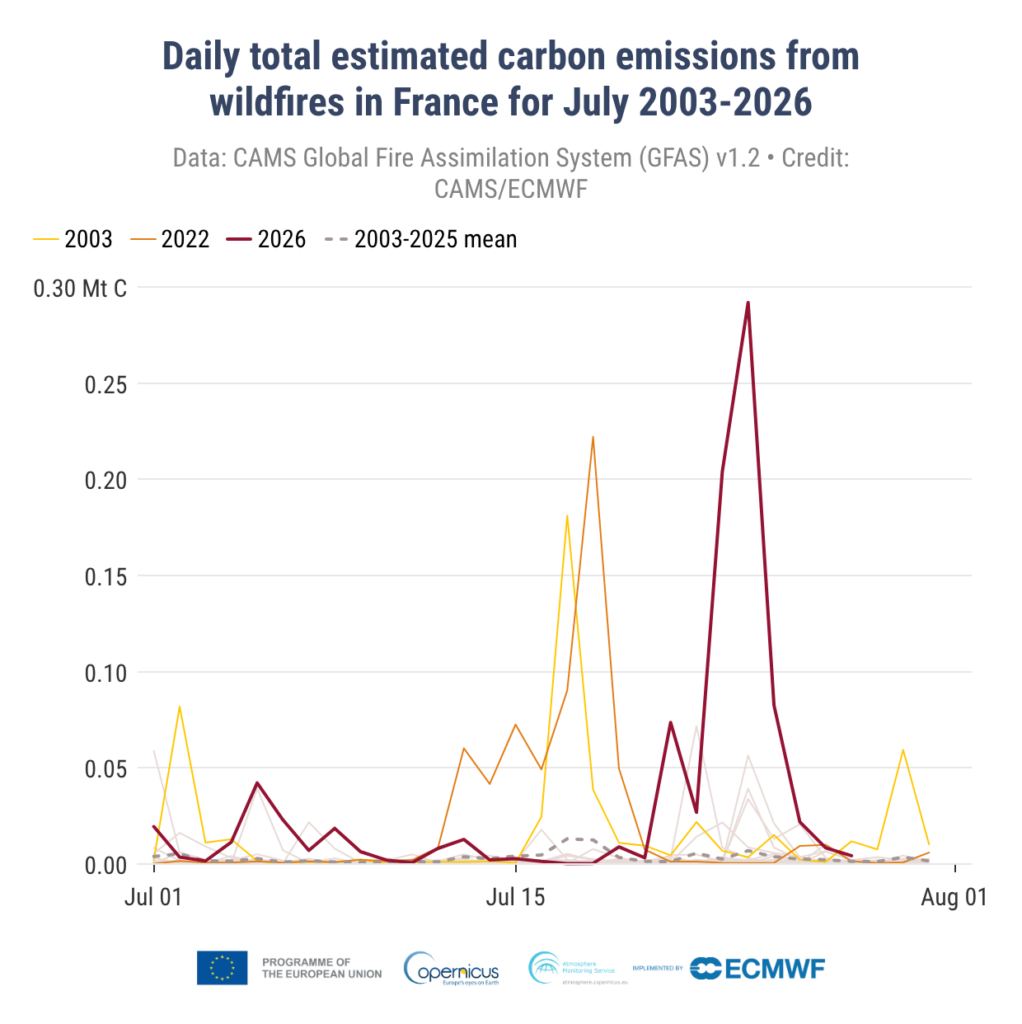
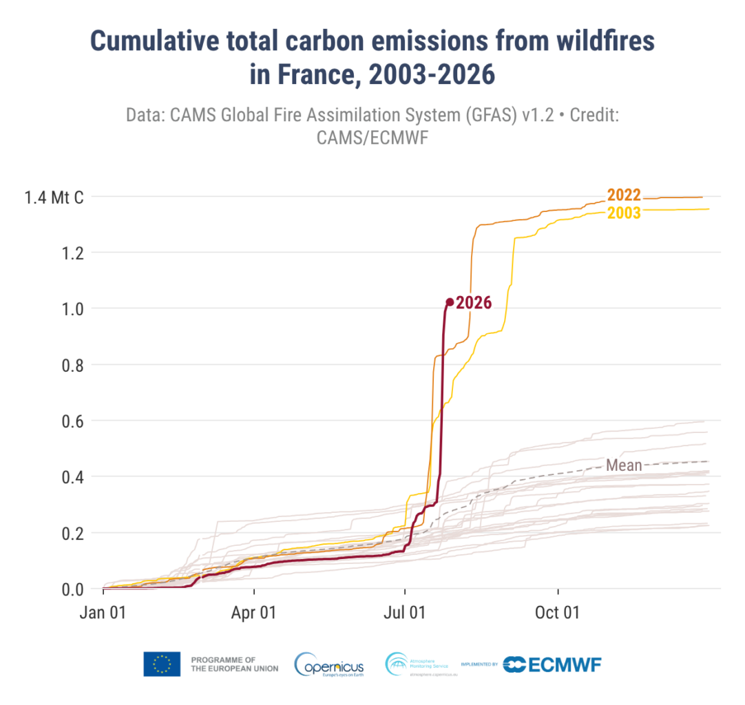
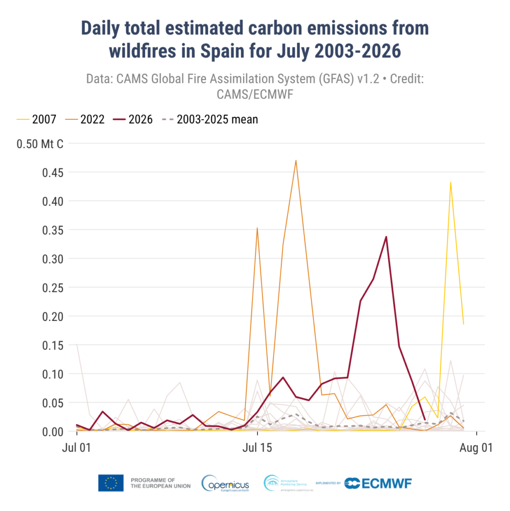
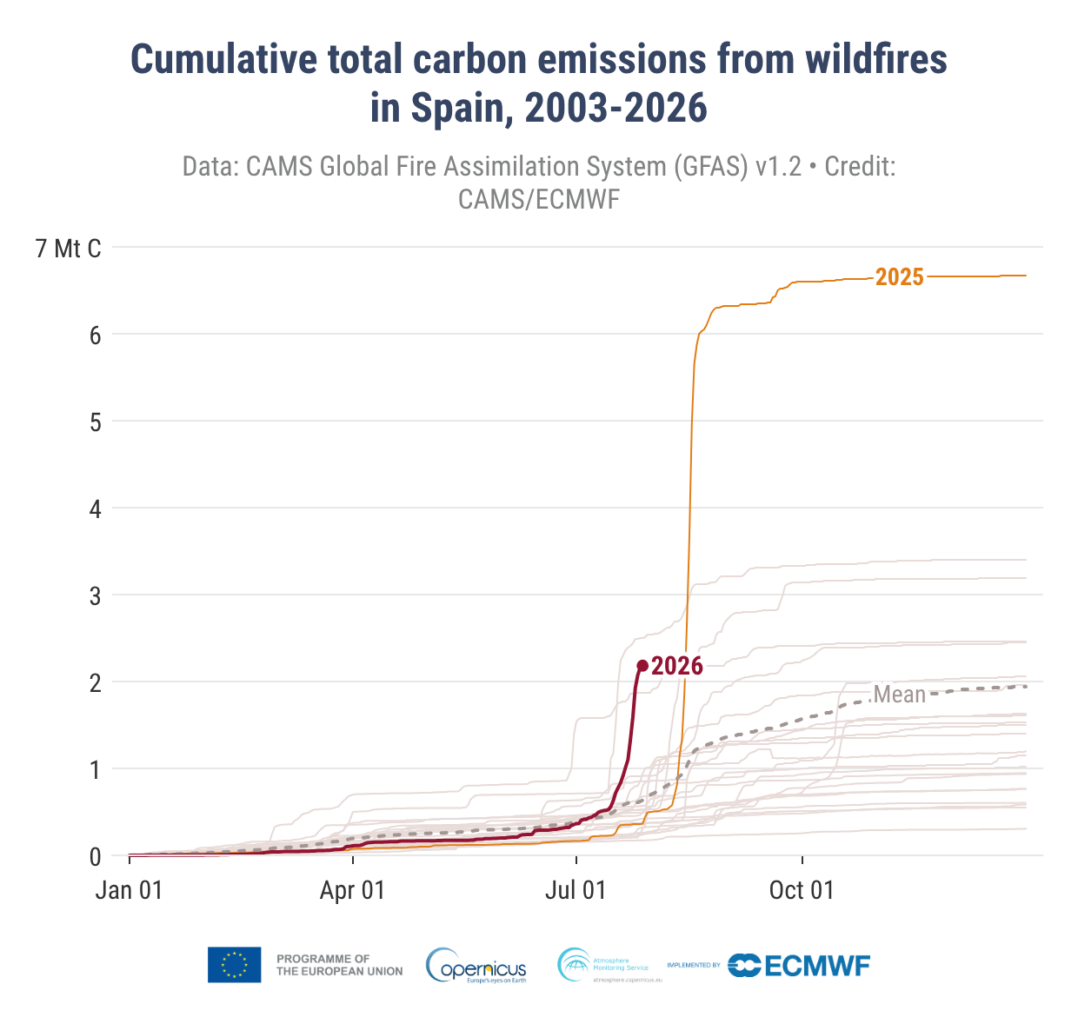
Figure 6: Carbon emission (Mt C) from wildfires expressed in daily totals since July 1st (left) and cumulated over the year (right), for France (top) and Spain (bottom), in GFASv1.2 (source: ECMWF/CAMS)
As a result of the massive emission of particulate and gaseous trace species from the wildfire, air quality was substantially degraded at large scale and for several days since the onset of the fire. The highest observed PM2.5 levels in the city of Bordeaux reached a daily mean value of 115 µg/m3 on 26th July, about the same as the levels observed in New York City during the intense Canadian fires in 2023 (Kelly, 2023). The hourly peaks reached much higher values, with up to 341 µg/m3 on 24th July (665 µg/m3 in terms of PM10, which includes coarser aerosol; see Figure 7). This is more than two times above the threshold of 140 µg/m3 PM2.5, starting from which air quality is considered extremely poor in the European Air Quality Index, and as much as 20 times more than the threshold of 15 µg/m3 below which air quality is considered “fair”. But the impacts were felt much further than the city of Bordeaux. With even 486 µg/m3 in Limoges (200 km away) and extremely poor PM2.5 levels up to 400 km downwind in the plume in the Auvergne-Rhone-Alpes region.
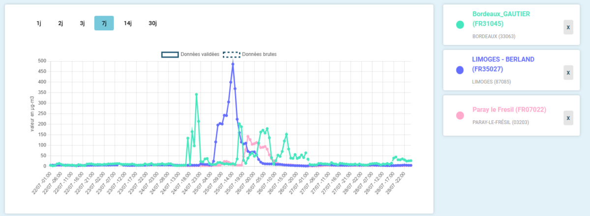
Figure 7: Observed hourly PM2.5 (µg/m3) levels in France in the Bordeaux area and up to 400 km downwind. (Source: geodair.fr)
The progress of the plume was followed and forecasted by operational air quality services at European (Copernicus Atmosphere Monitoring Service) and National Scale.
The French Air Quality Management relies on Copernicus Atmosphere Monitoring Service for background information about air quality in Europe, which is refined over France in the Prev’air Forecasting Platform that takes into account real time fire detection from space. These forecasts are provided to local observatories (in this case Atmo Nouvelle Aquitaine, for the Gironde Fire) that trigger air quality episodes so that emergency measures can be taken by the local authorities. During this intense fire, the health recommendations included avoiding outdoor activity and maximizing time indoors with reinforced isolation and close monitoring of persons at risk. For the first time during an ambient air pollution episode in France, the strategic national reserve of FFP2 masks was released and disseminated to local pharmacies with identified distribution priorities towards the most sensitive population (ARS, 2026a). Additional emergency measures targeting the residential sector, transportation, industrial activities and agriculture were also taken in Gironde to minimise other sources of pollution (Nouvelle Aquitaine, 2026b).
In Spain, nearly 100,000 people were confined to their homes because of the air quality (El País, 2026). For example, the towns of San Martín de Valdeiglesias and Villa del Prado are situated in the Sierra Oeste region of Madrid and were affected by the fires. The Madrid Regional Government operates air quality monitors in these municipalities (Comunidad de Madrid, 2026), which on 27th July detected a hourly concentration of PM10 of 357 µg/m³ in San Martín de Valdeiglesias and 185 µg/m³ in Villa del Prado; and a concentration of PM2.5 of 147 µg/m³ in Villa del Prado (see Figure 8). The average daily PM10 levels exceeded 100 µg/m³ in both towns, whilst the PM2.5 levels reached 96 µg/m³ in Villa del Prado on 26 July. The poor air quality led to a lockdown in both municipalities between 24 and 28 July (Comunidad de Madrid, 2026)
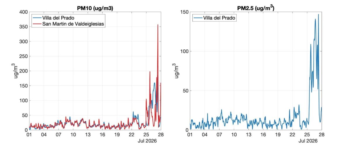
Figure 8: Provisional hourly PM10 (left) and PM2.5 (right) at Villa del Prado (station 28171001) and San Martín de Valdeiglesias (station 28133002), Comunidad de Madrid, 1–27 July 2026 (µg/m³). PM2.5 is available for Villa del Prado only. The sharp increase after ~25th July coincides with the wildfire affecting both municipalities.
Landuse Management
Changes in land use and land cover in Europe have increased fire risk, outpacing investments in fire prevention and suppression (Moreira et al., 2011).
In France, the Landes de Gascogne, at the center of the wildfire outbreak, are dominated by man-made pine forests planted at high density whose origins date back to the mid-1900s and which cover to date >800 000 ha (Mora et al. 2012). This area already suffered the largest and most devastating wildfire in France’s recent history in 1949 with 52,000 ha (or roughly half of the existing pine forests) being burnt and 82 persons killed (Christophe, 2009). Wildfire prevention and management also has a long history of fragmentation in the region, including tension between the national, local and individual levels over mandates and authority, though wildfire management has improved in recent decades. (Krasnodębski, 2022; Temple 2011; Blanchard, 1926). Probably as a consequence, Gironde province ranked first among French departments in terms of the number of fire outbreaks between 1991 and 2007 but considerably lower in terms of larger fires (Mora et al. 2012). Since the exceptional 2022 fire season in France in which over 62,000 ha were burned, the French government has further strengthened preparedness for wildfires, including increasing firefighting resources, improving evacuation plans, forecasting and warnings (Meteo France, 2026; Gironde Govt, 2023). The French government ran an awareness campaign in January 2026 to encourage brush clearing, which is legally required by homeowners within 200m of fire risk areas (Ministry of Ecology, 2026).
The Landes de Gascogne have generated a variety of economic benefits since their large-scale afforestation (Krasnodębski, 2022) and today remain at the center of the French timber industry sustaining >30,000 related employments and contributing to the estimated 10 billion EUR annual timber revenue of the Nouvelle-Aquitaine region (Nouvelle-Aquitaine, 2026). A diversification of the pine-focused sylviculture with less flammable broadleaf tree species could potentially help reduce fire risk (Jactel et al. 2017), yet it is hardly practiced due to the lower performance and economic rentability of such forests (Mora et al. 2012). The Landes de Gascogne area is also experiencing population growth in recent decades with nearly all of the 390 municipalities in the region recording population increases (Mora 2014), This demographic shift places more people in areas exposed to wildfire risks.
In Spain, like in many other places, Land Use and Land Cover (LULC) is also related to abandoning rural lands, and urbanisation. Research highlights changes in land management systems, including changing agriculture and where forests may have been substituted with more flammable vegetation (Monteil-Molina et al, 2019). Due to these abandonments, for example in Castello, over a 50 year period (until 2007), dense forests expanded from 17% to 28% (Delgado Artes et al, 2022). This potentially increases fire risk. Vegetation management, including prescribed burns, thinning and reforestation with less flammable species are among the strategies used in Spain to reduce risk (Keeping et al., 2025). While there is increasing focus on integrated landscape management, the current fires in 2026, have been beyond the coping capacity of local responses.
V&E conclusions
The 2026 wildfires in France and Spain demonstrate how growing human exposure, changing land use, and extreme fire behaviour are increasing wildfire impacts across southwestern Europe. Population growth and expansion into the wildland–urban interface have placed more people at risk, while the timing of the fires at the peak of the tourist season further complicated evacuations in affected areas.
The fires generated exceptionally high carbon emissions and widespread smoke pollution, causing hazardously poor air quality over large areas and prompting public health measures including confinement orders, air quality advisories and the distribution of FFP2 masks. Exposure to wildfire smoke poses significant respiratory, cardiovascular and mental health risks, particularly for vulnerable populations.
These impacts were exacerbated by landuse changes, including extensive flammable pine plantations in France and increasing forest density following rural land abandonment in Spain, highlighting the growing challenge of managing wildfire risk in increasingly populated and fire-prone landscapes.
Appendix
A1. Trends in burned area
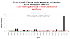
Figure A1.1: Total annual burned area (ha) from remote sensing over the Landes de Gascognes Forest from 1984 to 2025.
A2. DSR and related weather variables with climatology
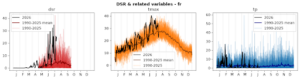
Figure A2.1: Daily severity rating (DSR), daily maximum temperatures (tmax) and daily precipitation (tp) over southwestern France. Black line shows 2026 values at time of writing; light coloured lines show 1990-2025 values; dark coloured lines show 1990-2025 mean. DSR data from CEMS, temperature and precipitation data from ERA5.
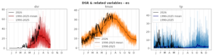
Figure A2.2: As Figure A2.1, but for central Spain region.